Al Jumūm geodata
Al Jumūm (Makkah) is a populated place; located in Saudi Arabia in Asia/Riyadh (GMT+3) time zone. With population of 22,207 people, there are 55 cities with bigger population in this country. Compared to other cities in Saudi Arabia, 74.2% of cities are located further ↑North; 85.6% of cities are located further →East and 53.6% of cities have higher elevation than Al Jumūm. Note1


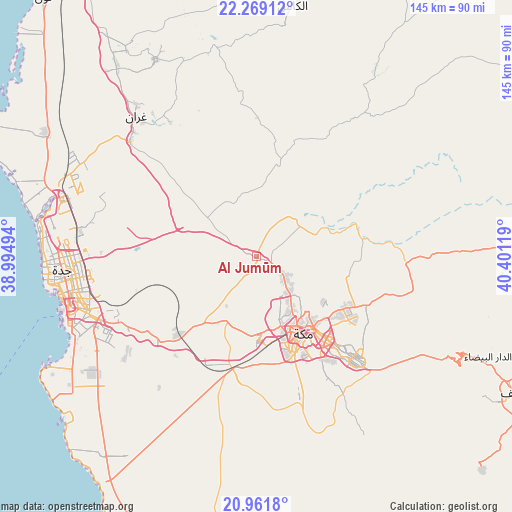
Al Jumūm GPS coordinates[2]
21° 37' 0.984" North, 39° 41' 53.016" East
| Map corner | latitude | longitude |
|---|---|---|
| Upper-left | 22.26912°, | 38.99494° |
| Center: | 21.61694°, | 39.69806° |
| Lower-right: | 20.9618°, | 40.40119° |
| Map W x H: | 145.4×145.4 km | = 90.3×90.3mi |
| max Lat: | 31.67252° ⇑74.2% North |
| Al Jumūm: | 21.61694° |
| min Lat: | ⇓25.8% South 16.57946° |
| min Long | Al Jumūm | max Long |
| 35.69014° | 39.69806° | 54.09599° |
| W 14.4%⇐ | ⇒85.6% E |
Elevation
Elevation of Al Jumūm is 204 m = 669 ft, and this is 317.4 m = 1041 ft below average elevation for this country.
| Max E: |
2385 m = 7825 ft | 53.6% |
| Avg. | 521.4 m = 1711 ft | |
| Al Jumūm | 204 m = 669 ft | |
Min E: |
3 m = 10 ft | 46.4% |
See also: Saudi Arabia elevation on elevation.city.
Geographical zone
Al Jumūm is located in North Torrid zone (between Equator and Tropic of Cancer). Distance of this Northern Tropic circle is 202.3 km =125.7 mi to North.| Distance of | km | miles | from Al Jumūm |
|---|---|---|---|
| North Pole | 7603.5 | 4724.6 | to North |
| Arctic Circle | 4997.6 | 3105.4 | to North |
| Tropic Cancer | 202.3 | 125.7 | to North |
| Equator | 2403.6 | 1493.5 | to South |


Nearby cities:
15 places around Al Jumūm: (largest is in red/bold)
• Al Bahah
256.2 km =159.2 mi,  134°
134°
• Al Hadā
66.9 km =41.6 mi,  114°
114°
• Al Mindak
231.1 km =143.6 mi, 134°
• Al Muwayh
230.9 km =143.5 mi,  66°
66°
• Ash Shafā
87.8 km =54.6 mi, 133°
• Badr Ḩunayn
258.2 km =160.4 mi,  338°
338°
• Jeddah
52.4 km =32.6 mi,  260°
260°
• Mecca
24.9 km =15.5 mi,  148°
148°
• Medina
317.2 km =197.1 mi,  358°
358°
• Rābigh
148.1 km =92 mi,  332°
332°
• Sulţānah
319.9 km =198.8 mi, 357°
• Tabālah
336.5 km =209.1 mi,  123°
123°
• Ta’if
83.7 km =52 mi, 117°
• Turabah
205.2 km =127.5 mi,  102°
102°
• Yanbu
322 km =200.1 mi, 328°
Sources, notices
• [Note1] Compared only with cities in Saudi Arabia existing in our database
• [Src1] Map data: © OpenStreetMap contributors (CC-BY-SA)
• [Src2] Other city data from geonames.org with taken over terms of usage.
• [Src3] Geographical zone / Annual Mean Temperature by Robert A. Rohde @ Wikipedia
