Mecca geodata
Mecca (Makkah) is a seat of a first-order administrative division; located in Saudi Arabia in Asia/Riyadh (GMT+3) time zone. With population of 1,323,624 people, there are 2 cities with bigger population in this country. Compared to other cities in Saudi Arabia, 76.3% of cities are located further ↑North; 84.5% of cities are located further →East and 51.5% of cities have higher elevation than Mecca. Note1


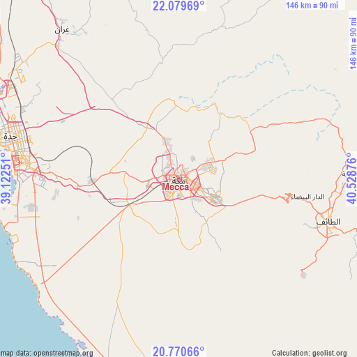
Mecca GPS coordinates[2]
21° 25' 35.904" North, 39° 49' 32.268" East
| Map corner | latitude | longitude |
|---|---|---|
| Upper-left | 22.07969°, | 39.12251° |
| Center: | 21.42664°, | 39.82563° |
| Lower-right: | 20.77066°, | 40.52876° |
| Map W x H: | 145.6×145.6 km | = 90.5×90.5mi |
| max Lat: | 31.67252° ⇑76.3% North |
| Mecca: | 21.42664° |
| min Lat: | ⇓23.7% South 16.57946° |
| min Long | Mecca | max Long |
| 35.69014° | 39.82563° | 54.09599° |
| W 15.5%⇐ | ⇒84.5% E |
Elevation
Elevation of Mecca is 333 m = 1093 ft, and this is 188.4 m = 618 ft below average elevation for this country.
| Max E: |
2385 m = 7825 ft | 51.5% |
| Avg. | 521.4 m = 1711 ft | |
| Mecca | 333 m = 1093 ft | |
Min E: |
3 m = 10 ft | 48.5% |
See also: Mecca elevation on elevation.city.
Geographical zone
Mecca is located in North Torrid zone (between Equator and Tropic of Cancer). Distance of this Northern Tropic circle is 223.5 km =138.9 mi to North.| Distance of | km | miles | from Mecca |
|---|---|---|---|
| North Pole | 7624.6 | 4737.7 | to North |
| Arctic Circle | 5018.8 | 3118.5 | to North |
| Tropic Cancer | 223.5 | 138.9 | to North |
| Equator | 2382.4 | 1480.4 | to South |


Nearby cities:
15 places around Mecca: (largest is in red/bold)
• Al Bahah
232.1 km =144.2 mi,  132°
132°
• Al Hadā
48.2 km =30 mi,  97°
97°
• Al Jumūm
24.9 km =15.5 mi,  328°
328°
• Al Majāridah
336 km =208.8 mi,  139°
139°
• Al Mindak
207 km =128.6 mi, 132°
• Al Muwayh
228.6 km =142 mi,  60°
60°
• Ash Shafā
64 km =39.8 mi, 128°
• Badr Ḩunayn
282.7 km =175.7 mi,  337°
337°
• Jeddah
66.2 km =41.1 mi,  281°
281°
• Medina
338.9 km =210.6 mi,  356°
356°
• Qal‘at Bīshah
329.7 km =204.9 mi,  118°
118°
• Rābigh
172.9 km =107.4 mi, 331°
• Tabālah
314.1 km =195.2 mi, 121°
• Ta’if
63.5 km =39.5 mi,  105°
105°
• Turabah
188.7 km =117.3 mi, 97°
In other languages:
- In Spanish: La Meca
- In France: La Mecque
- In German: Mekka
- In Italian: La Mecca
- In Russian: Мекка
Sources, notices
• [Note1] Compared only with cities in Saudi Arabia existing in our database
• [Src1] Map data: © OpenStreetMap contributors (CC-BY-SA)
• [Src2] Other city data from geonames.org with taken over terms of usage.
• [Src3] Geographical zone / Annual Mean Temperature by Robert A. Rohde @ Wikipedia
