Medina geodata
Medina (Al Madīnah al Munawwarah) is a seat of a first-order administrative division; located in Saudi Arabia in Asia/Riyadh (GMT+3) time zone. With population of 1,300,000 people, there are 3 cities with bigger population in this country. Compared to other cities in Saudi Arabia, 64.9% of cities are located further ↑North; 86.6% of cities are located further →East and 60.8% of cities have lower elevation than Medina. Note1


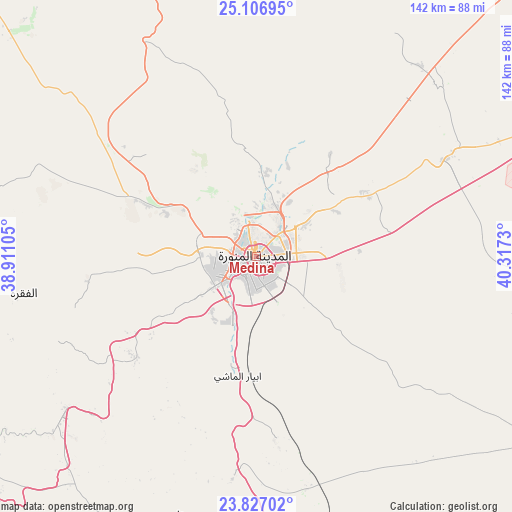
Medina GPS coordinates[2]
24° 28' 6.996" North, 39° 36' 51.012" East
| Map corner | latitude | longitude |
|---|---|---|
| Upper-left | 25.10695°, | 38.91105° |
| Center: | 24.46861°, | 39.61417° |
| Lower-right: | 23.82702°, | 40.3173° |
| Map W x H: | 142.3×142.3 km | = 88.4×88.4mi |
| max Lat: | 31.67252° ⇑64.9% North |
| Medina: | 24.46861° |
| min Lat: | ⇓35.1% South 16.57946° |
| min Long | Medina | max Long |
| 35.69014° | 39.61417° | 54.09599° |
| W 13.4%⇐ | ⇒86.6% E |
Elevation
Elevation of Medina is 603 m = 1978 ft, and this is 81.6 m = 268 ft above average elevation for this country.
| Max E: |
2385 m = 7825 ft | 39.2% |
| Medina | 603 m 1978 ft | |
| Avg. | 521.4 m = 1711 ft | |
Min E: |
3 m = 10 ft | 60.8% |
See also: Medina elevation on elevation.city.
Geographical zone
Medina is located in North temperate zone (between Tropic of Cancer and the Arctic Circle). Distance of this Northern Tropic circle is 114.7 km =71.3 mi to South.| Distance of | km | miles | from Medina |
|---|---|---|---|
| North Pole | 7286.4 | 4527.6 | to North |
| Arctic Circle | 4680.5 | 2908.3 | to North |
| Tropic Cancer | 114.7 | 71.3 | to South |
| Equator | 2720.7 | 1690.6 | to South |


Nearby cities:
15 places around Medina: (largest is in red/bold)
• Afif
340.8 km =211.8 mi,  100°
100°
• Al Hadā
351.6 km =218.5 mi,  168°
168°
• Al Jumūm
317.2 km =197.1 mi,  178°
178°
• Al Muwayh
314.7 km =195.5 mi,  135°
135°
• Al-`Ula
292.2 km =181.6 mi,  324°
324°
• Alrmtheiah
339.1 km =210.7 mi,  84°
84°
• Badr Ḩunayn
113.1 km =70.3 mi,  227°
227°
• Jeddah
328.1 km =203.9 mi,  187°
187°
• Mecca
338.9 km =210.6 mi, 176°
• Rābigh
194.8 km =121 mi,  197°
197°
• Sulţānah
3.9 km =2.4 mi,  312°
312°
• Ta’if
365 km =226.8 mi, 166°
• Umm Lajj
244.7 km =152 mi,  284°
284°
• Wed Alnkil
341.7 km =212.3 mi,  71°
71°
• Yanbu
162.9 km =101.2 mi,  255°
255°
Sources, notices
• [Note1] Compared only with cities in Saudi Arabia existing in our database
• [Src1] Map data: © OpenStreetMap contributors (CC-BY-SA)
• [Src2] Other city data from geonames.org with taken over terms of usage.
• [Src3] Geographical zone / Annual Mean Temperature by Robert A. Rohde @ Wikipedia
