Kuacjok geodata
Kuacjok (Gogrial) is a seat of a first-order administrative division; located in South Sudan in Africa/Juba (GMT+2) time zone. In our database, there are 19 cities with bigger population. Compared to other cities in South Sudan, 60.6% of cities are located further ↓South; 87.9% of cities are located further →East and 51.5% of cities have higher elevation than Kuacjok. Note1


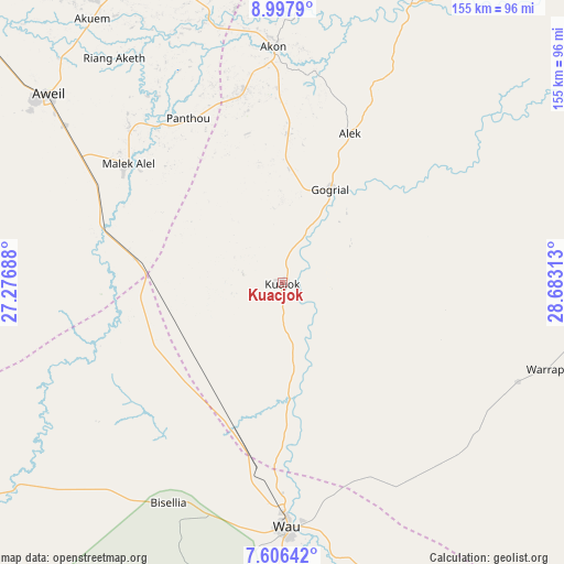
Kuacjok GPS coordinates[2]
8° 18' 10.008" North, 27° 58' 48" East
| Map corner | latitude | longitude |
|---|---|---|
| Upper-left | 8.9979°, | 27.27688° |
| Center: | 8.30278°, | 27.98° |
| Lower-right: | 7.60642°, | 28.68313° |
| Map W x H: | 154.7×154.7 km | = 96.1×96.1mi |
| max Lat: | 11.7431° ⇑39.4% North |
| Kuacjok: | 8.30278° |
| min Lat: | ⇓60.6% South 3.86512° |
| min Long | Kuacjok | max Long |
| 25.67833° | 27.98° | 33.92621° |
| W 12.1%⇐ | ⇒87.9% E |
Elevation
Elevation of Kuacjok is 428 m = 1404 ft, and this is 60.9 m = 200 ft below average elevation for this country.
| Max E: |
836 m = 2743 ft | 51.5% |
| Avg. | 488.9 m = 1604 ft | |
| Kuacjok | 428 m = 1404 ft | |
Min E: |
392 m = 1286 ft | 48.5% |
See also: South Sudan elevation on elevation.city.
Geographical zone
Kuacjok is located in North Torrid zone (between Equator and Tropic of Cancer). Distance of Equator is 923.2 km =573.6 mi to South.| Distance of | km | miles | from Kuacjok |
|---|---|---|---|
| North Pole | 9083.9 | 5644.5 | to North |
| Arctic Circle | 6478 | 4025.2 | to North |
| Tropic Cancer | 1682.7 | 1045.6 | to North |
| Equator | 923.2 | 573.6 | to South |


Nearby cities:
15 places around Kuacjok: (largest is in red/bold)
• Aweil
82.4 km =51.2 mi,  308°
308°
• Ayod
377.9 km =234.8 mi,  93°
93°
• Bentiu
226.2 km =140.6 mi,  62°
62°
• Cueibet
199 km =123.7 mi,  135°
135°
• Gogrial
28.8 km =17.9 mi,  27°
27°
• Leer
237.7 km =147.7 mi, 89°
• Mayen Abun
101 km =62.8 mi,  23°
23°
• Pariang
283.6 km =176.2 mi,  50°
50°
• Raja
253.8 km =157.7 mi,  274°
274°
• Rumbek
250.4 km =155.6 mi,  131°
131°
• Tambura
305.8 km =190 mi,  190°
190°
• Tonj
137.8 km =85.6 mi,  146°
146°
• Wau
66.9 km =41.6 mi,  179°
179°
• Winejok
90.8 km =56.4 mi,  330°
330°
• Yirol
339 km =210.6 mi, 125°
Sources, notices
• [Note1] Compared only with cities in South Sudan existing in our database
• [Src1] Map data: © OpenStreetMap contributors (CC-BY-SA)
• [Src2] Other city data from geonames.org with taken over terms of usage.
• [Src3] Geographical zone / Annual Mean Temperature by Robert A. Rohde @ Wikipedia
