Aweil geodata
Aweil is a seat of a first-order administrative division; located in South Sudan in Africa/Juba (GMT+2) time zone. With population of 38,745 people, there are 7 cities with bigger population in this country. Compared to other cities in South Sudan, 78.8% of cities are located further ↓South; 97% of cities are located further →East and 54.5% of cities have higher elevation than Aweil. Note1


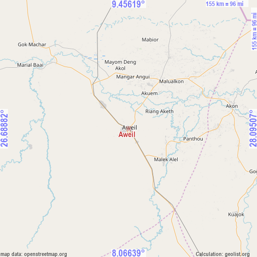
Aweil GPS coordinates[2]
8° 45' 42.984" North, 27° 23' 30.984" East
| Map corner | latitude | longitude |
|---|---|---|
| Upper-left | 9.45619°, | 26.68882° |
| Center: | 8.76194°, | 27.39194° |
| Lower-right: | 8.06639°, | 28.09507° |
| Map W x H: | 154.5×154.5 km | = 96×96mi |
| max Lat: | 11.7431° ⇑21.2% North |
| Aweil: | 8.76194° |
| min Lat: | ⇓78.8% South 3.86512° |
| min Long | Aweil | max Long |
| 25.67833° | 27.39194° | 33.92621° |
| W 3%⇐ | ⇒97% E |
Elevation
Elevation of Aweil is 425 m = 1394 ft, and this is 63.9 m = 210 ft below average elevation for this country.
| Max E: |
836 m = 2743 ft | 54.5% |
| Avg. | 488.9 m = 1604 ft | |
| Aweil | 425 m = 1394 ft | |
Min E: |
392 m = 1286 ft | 45.5% |
See also: South Sudan elevation on elevation.city.
Geographical zone
Aweil is located in North Torrid zone (between Equator and Tropic of Cancer). Distance of Equator is 974.2 km =605.3 mi to South.| Distance of | km | miles | from Aweil |
|---|---|---|---|
| North Pole | 9032.8 | 5612.7 | to North |
| Arctic Circle | 6426.9 | 3993.5 | to North |
| Tropic Cancer | 1631.7 | 1013.9 | to North |
| Equator | 974.2 | 605.3 | to South |


Nearby cities:
14 places around Aweil: (largest is in red/bold)
• Bentiu
269.9 km =167.7 mi,  78°
78°
• Cueibet
280.9 km =174.5 mi,  133°
133°
• Gogrial
81.9 km =50.9 mi,  108°
108°
• Kuacjok
82.4 km =51.2 mi, 128°
• Leer
306.5 km =190.5 mi,  99°
99°
• Mayen Abun
112.7 km =70 mi,  68°
68°
• Pariang
311.7 km =193.7 mi, 65°
• Raja
191.2 km =118.8 mi,  260°
260°
• Rumbek
332.7 km =206.7 mi, 130°
• Tambura
351.7 km =218.5 mi,  178°
178°
• Tonj
217.7 km =135.3 mi,  139°
139°
• Wau
135.1 km =83.9 mi,  150°
150°
• Winejok
34.1 km =21.2 mi,  35°
35°
• Yirol
421.3 km =261.8 mi, 125°
Sources, notices
• [Note1] Compared only with cities in South Sudan existing in our database
• [Src1] Map data: © OpenStreetMap contributors (CC-BY-SA)
• [Src2] Other city data from geonames.org with taken over terms of usage.
• [Src3] Geographical zone / Annual Mean Temperature by Robert A. Rohde @ Wikipedia
