Massaguet geodata
Massaguet (Hadjer-Lamis) is a populated place; located in Chad in Africa/Ndjamena (GMT+1) time zone. With population of 17,906 people, there are 17 cities with bigger population in this country. Compared to other cities in Chad, 63.8% of cities are located further ↓South; 83% of cities are located further →East and 93.6% of cities have higher elevation than Massaguet. Note1


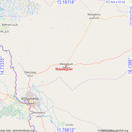
Massaguet GPS coordinates[2]
12° 28' 31.944" North, 15° 26' 11.292" East
| Map corner | latitude | longitude |
|---|---|---|
| Upper-left | 13.16114°, | 14.73335° |
| Center: | 12.47554°, | 15.43647° |
| Lower-right: | 11.78812°, | 16.1396° |
| Map W x H: | 152.7×152.7 km | = 94.9×94.9mi |
| max Lat: | 21.8375° ⇑36.2% North |
| Massaguet: | 12.47554° |
| min Lat: | ⇓63.8% South 8.26681° |
| min Long | Massaguet | max Long |
| 14.1539° | 15.43647° | 22.84308° |
| W 17%⇐ | ⇒83% E |
Elevation
Elevation of Massaguet is 292 m = 958 ft, and this is 145.3 m = 477 ft below average elevation for this country.
| Max E: |
1046 m = 3432 ft | 93.6% |
| Avg. | 437.3 m = 1435 ft | |
| Massaguet | 292 m = 958 ft | |
Min E: |
242 m = 794 ft | 6.4% |
See also: Chad elevation on elevation.city.
Geographical zone
Massaguet is located in North Torrid zone (between Equator and Tropic of Cancer). Distance of this Northern Tropic circle is 1218.8 km =757.3 mi to North.| Distance of | km | miles | from Massaguet |
|---|---|---|---|
| North Pole | 8619.9 | 5356.2 | to North |
| Arctic Circle | 6014 | 3736.9 | to North |
| Tropic Cancer | 1218.8 | 757.3 | to North |
| Equator | 1387.2 | 862 | to South |


Nearby cities:
15 places around Massaguet: (largest is in red/bold)
• Bitkine
306.8 km =190.6 mi,  100°
100°
• Bokoro
176.5 km =109.7 mi,  93°
93°
• Bol
135.2 km =84 mi,  324°
324°
• Bongor
244.2 km =151.7 mi,  181°
181°
• Bousso
261.3 km =162.4 mi,  147°
147°
• Dourbali
87.9 km =54.6 mi, 147°
• Guelendeng
173.7 km =107.9 mi, 175°
• Mao
183.5 km =114 mi,  355°
355°
• Massakory
66 km =41 mi,  28°
28°
• Massenya
143.4 km =89.1 mi, 146°
• Melfi
314.3 km =195.3 mi,  120°
120°
• Moussoro
172.7 km =107.3 mi,  41°
41°
• N'Djamena
59.1 km =36.7 mi,  226°
226°
• Ngama
203.2 km =126.3 mi,  112°
112°
• Vadanakallu
233.2 km =144.9 mi, 324°
Sources, notices
• [Note1] Compared only with cities in Chad existing in our database
• [Src1] Map data: © OpenStreetMap contributors (CC-BY-SA)
• [Src2] Other city data from geonames.org with taken over terms of usage.
• [Src3] Geographical zone / Annual Mean Temperature by Robert A. Rohde @ Wikipedia
