Dourbali geodata
Dourbali (Chari-Baguirmi) is a populated place; located in Chad in Africa/Ndjamena (GMT+1) time zone. With population of 17,682 people, there are 18 cities with bigger population in this country. Compared to other cities in Chad, 51.1% of cities are located further ↓South; 72.3% of cities are located further →East and 80.9% of cities have higher elevation than Dourbali. Note1


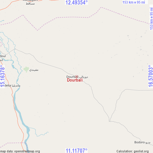
Dourbali GPS coordinates[2]
11° 48' 22.212" North, 15° 52' 0.84" East
| Map corner | latitude | longitude |
|---|---|---|
| Upper-left | 12.49354°, | 15.16378° |
| Center: | 11.80617°, | 15.8669° |
| Lower-right: | 11.11707°, | 16.57003° |
| Map W x H: | 153×153.1 km | = 95.1×95.1mi |
| max Lat: | 21.8375° ⇑48.9% North |
| Dourbali: | 11.80617° |
| min Lat: | ⇓51.1% South 8.26681° |
| min Long | Dourbali | max Long |
| 14.1539° | 15.8669° | 22.84308° |
| W 27.7%⇐ | ⇒72.3% E |
Elevation
Elevation of Dourbali is 305 m = 1001 ft, and this is 132.3 m = 434 ft below average elevation for this country.
| Max E: |
1046 m = 3432 ft | 80.9% |
| Avg. | 437.3 m = 1435 ft | |
| Dourbali | 305 m = 1001 ft | |
Min E: |
242 m = 794 ft | 19.1% |
See also: Chad elevation on elevation.city.
Geographical zone
Dourbali is located in North Torrid zone (between Equator and Tropic of Cancer). Distance of this Northern Tropic circle is 1293.2 km =803.6 mi to North.| Distance of | km | miles | from Dourbali |
|---|---|---|---|
| North Pole | 8694.3 | 5402.4 | to North |
| Arctic Circle | 6088.5 | 3783.2 | to North |
| Tropic Cancer | 1293.2 | 803.6 | to North |
| Equator | 1312.7 | 815.7 | to South |


Nearby cities:
15 places around Dourbali: (largest is in red/bold)
• Bitkine
256.1 km =159.1 mi,  85°
85°
• Bokoro
144.3 km =89.7 mi,  63°
63°
• Bol
223.1 km =138.6 mi,  325°
325°
• Bongor
178 km =110.6 mi,  197°
197°
• Bousso
173.4 km =107.7 mi,  147°
147°
• Gounou Gaya
245.1 km =152.3 mi,  189°
189°
• Guelendeng
104.7 km =65.1 mi, 199°
• Mao
264.4 km =164.3 mi,  346°
346°
• Massaguet
87.9 km =54.6 mi, 327°
• Massakory
133.1 km =82.7 mi, 353°
• Massenya
55.6 km =34.5 mi,  143°
143°
• Melfi
240.2 km =149.3 mi,  110°
110°
• Moussoro
214.9 km =133.5 mi,  18°
18°
• N'Djamena
95.5 km =59.3 mi,  290°
290°
• Ngama
141.5 km =87.9 mi, 91°
Sources, notices
• [Note1] Compared only with cities in Chad existing in our database
• [Src1] Map data: © OpenStreetMap contributors (CC-BY-SA)
• [Src2] Other city data from geonames.org with taken over terms of usage.
• [Src3] Geographical zone / Annual Mean Temperature by Robert A. Rohde @ Wikipedia
