Ngama geodata
Ngama (Chari-Baguirmi) is a populated place; located in Chad in Africa/Ndjamena (GMT+1) time zone. With population of 12,438 people, there are 29 cities with bigger population in this country. Compared to other cities in Chad, 51.1% of cities are located further ↑North; 55.3% of cities are located further ←West and 76.6% of cities have higher elevation than Ngama. Note1


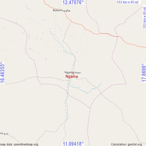
Ngama GPS coordinates[2]
11° 46' 59.988" North, 17° 10' 0.012" East
| Map corner | latitude | longitude |
|---|---|---|
| Upper-left | 12.47076°, | 16.46355° |
| Center: | 11.78333°, | 17.16667° |
| Lower-right: | 11.09418°, | 17.8698° |
| Map W x H: | 153.1×153.1 km | = 95.1×95.1mi |
| max Lat: | 21.8375° ⇑51.1% North |
| Ngama: | 11.78333° |
| min Lat: | ⇓48.9% South 8.26681° |
| min Long | Ngama | max Long |
| 14.1539° | 17.16667° | 22.84308° |
| W 55.3%⇐ | ⇒44.7% E |
Elevation
Elevation of Ngama is 326 m = 1070 ft, and this is 111.3 m = 365 ft below average elevation for this country.
| Max E: |
1046 m = 3432 ft | 76.6% |
| Avg. | 437.3 m = 1435 ft | |
| Ngama | 326 m = 1070 ft | |
Min E: |
242 m = 794 ft | 23.4% |
See also: Chad elevation on elevation.city.
Geographical zone
Ngama is located in North Torrid zone (between Equator and Tropic of Cancer). Distance of this Northern Tropic circle is 1295.7 km =805.1 mi to North.| Distance of | km | miles | from Ngama |
|---|---|---|---|
| North Pole | 8696.9 | 5404 | to North |
| Arctic Circle | 6091 | 3784.8 | to North |
| Tropic Cancer | 1295.7 | 805.1 | to North |
| Equator | 1310.2 | 814.1 | to South |


Nearby cities:
15 places around Ngama: (largest is in red/bold)
• Ati
203.6 km =126.5 mi,  38°
38°
• Bitkine
116 km =72.1 mi,  79°
79°
• Bokoro
67.2 km =41.8 mi,  349°
349°
• Bongor
257.4 km =159.9 mi,  229°
229°
• Bousso
152.7 km =94.9 mi,  199°
199°
• Dourbali
141.5 km =87.9 mi,  271°
271°
• Goundi
270 km =167.8 mi,  175°
175°
• Guelendeng
200.8 km =124.8 mi,  241°
241°
• Massaguet
203.2 km =126.3 mi,  292°
292°
• Massakory
206.3 km =128.2 mi,  310°
310°
• Massenya
116.4 km =72.3 mi,  248°
248°
• Melfi
116.2 km =72.2 mi,  133°
133°
• Mongo
171.9 km =106.8 mi,  74°
74°
• Moussoro
219.3 km =136.3 mi,  340°
340°
• N'Djamena
233.6 km =145.2 mi,  278°
278°
Sources, notices
• [Note1] Compared only with cities in Chad existing in our database
• [Src1] Map data: © OpenStreetMap contributors (CC-BY-SA)
• [Src2] Other city data from geonames.org with taken over terms of usage.
• [Src3] Geographical zone / Annual Mean Temperature by Robert A. Rohde @ Wikipedia
