Massakory geodata
Massakory (Hadjer-Lamis) is a seat of a first-order administrative division; located in Chad in Africa/Ndjamena (GMT+1) time zone. With population of 15,406 people, there are 22 cities with bigger population in this country. Compared to other cities in Chad, 66% of cities are located further ↓South; 76.6% of cities are located further →East and 97.9% of cities have higher elevation than Massakory. Note1


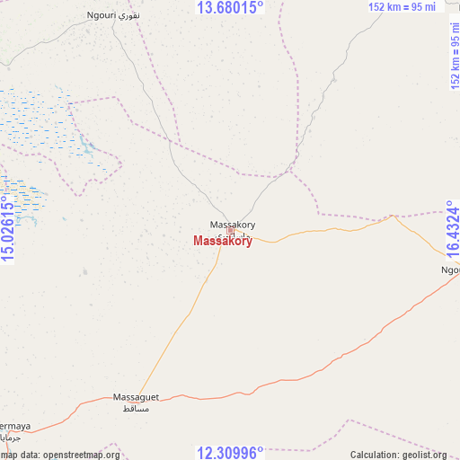
Massakory GPS coordinates[2]
12° 59' 45.6" North, 15° 43' 45.372" East
| Map corner | latitude | longitude |
|---|---|---|
| Upper-left | 13.68015°, | 15.02615° |
| Center: | 12.996°, | 15.72927° |
| Lower-right: | 12.30996°, | 16.4324° |
| Map W x H: | 152.4×152.4 km | = 94.7×94.7mi |
| max Lat: | 21.8375° ⇑34% North |
| Massakory: | 12.996° |
| min Lat: | ⇓66% South 8.26681° |
| min Long | Massakory | max Long |
| 14.1539° | 15.72927° | 22.84308° |
| W 23.4%⇐ | ⇒76.6% E |
Elevation
Elevation of Massakory is 287 m = 942 ft, and this is 150.3 m = 493 ft below average elevation for this country.
| Max E: |
1046 m = 3432 ft | 97.9% |
| Avg. | 437.3 m = 1435 ft | |
| Massakory | 287 m = 942 ft | |
Min E: |
242 m = 794 ft | 2.1% |
See also: Chad elevation on elevation.city.
Geographical zone
Massakory is located in North Torrid zone (between Equator and Tropic of Cancer). Distance of this Northern Tropic circle is 1160.9 km =721.3 mi to North.| Distance of | km | miles | from Massakory |
|---|---|---|---|
| North Pole | 8562 | 5320.2 | to North |
| Arctic Circle | 5956.2 | 3701 | to North |
| Tropic Cancer | 1160.9 | 721.3 | to North |
| Equator | 1445 | 897.9 | to South |


Nearby cities:
15 places around Massakory: (largest is in red/bold)
• Ati
283.3 km =176 mi,  85°
85°
• Bitkine
292.4 km =181.7 mi,  112°
112°
• Bokoro
159.7 km =99.2 mi,  115°
115°
• Bol
121.8 km =75.7 mi,  295°
295°
• Bongor
304.4 km =189.1 mi,  187°
187°
• Bousso
299 km =185.8 mi,  159°
159°
• Dourbali
133.1 km =82.7 mi,  173°
173°
• Guelendeng
231.9 km =144.1 mi,  184°
184°
• Mao
133.1 km =82.7 mi,  340°
340°
• Massaguet
66 km =41 mi,  208°
208°
• Massenya
183.4 km =114 mi, 164°
• Moussoro
109.2 km =67.9 mi,  48°
48°
• N'Djamena
123.7 km =76.9 mi,  216°
216°
• Ngama
206.3 km =128.2 mi,  130°
130°
• Vadanakallu
213 km =132.4 mi,  308°
308°
Sources, notices
• [Note1] Compared only with cities in Chad existing in our database
• [Src1] Map data: © OpenStreetMap contributors (CC-BY-SA)
• [Src2] Other city data from geonames.org with taken over terms of usage.
• [Src3] Geographical zone / Annual Mean Temperature by Robert A. Rohde @ Wikipedia
