Koumra geodata
Koumra (Mandoul) is a seat of a first-order administrative division; located in Chad in Africa/Ndjamena (GMT+1) time zone. With population of 36,263 people, there are 5 cities with bigger population in this country. Compared to other cities in Chad, 87.2% of cities are located further ↑North; 61.7% of cities are located further ←West and 59.6% of cities have lower elevation than Koumra. Note1


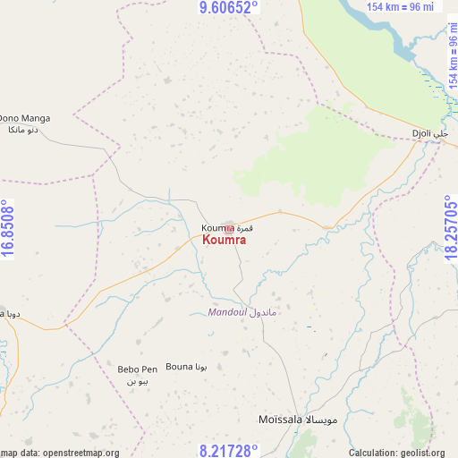
Koumra GPS coordinates[2]
8° 54' 45.216" North, 17° 33' 14.112" East
| Map corner | latitude | longitude |
|---|---|---|
| Upper-left | 9.60652°, | 16.8508° |
| Center: | 8.91256°, | 17.55392° |
| Lower-right: | 8.21728°, | 18.25705° |
| Map W x H: | 154.5×154.5 km | = 96×96mi |
| max Lat: | 21.8375° ⇑87.2% North |
| Koumra: | 8.91256° |
| min Lat: | ⇓12.8% South 8.26681° |
| min Long | Koumra | max Long |
| 14.1539° | 17.55392° | 22.84308° |
| W 61.7%⇐ | ⇒38.3% E |
Elevation
Elevation of Koumra is 399 m = 1309 ft, and this is 38.3 m = 126 ft below average elevation for this country.
| Max E: |
1046 m = 3432 ft | 40.4% |
| Avg. | 437.3 m = 1435 ft | |
| Koumra | 399 m = 1309 ft | |
Min E: |
242 m = 794 ft | 59.6% |
See also: Chad elevation on elevation.city.
Geographical zone
Koumra is located in North Torrid zone (between Equator and Tropic of Cancer). Distance of Equator is 991 km =615.8 mi to South.| Distance of | km | miles | from Koumra |
|---|---|---|---|
| North Pole | 9016.1 | 5602.3 | to North |
| Arctic Circle | 6410.2 | 3983.1 | to North |
| Tropic Cancer | 1614.9 | 1003.5 | to North |
| Equator | 991 | 615.8 | to South |


Nearby cities:
15 places around Koumra: (largest is in red/bold)
• Benoy
135.8 km =84.4 mi,  273°
273°
• Beïnamar
240.3 km =149.3 mi,  263°
263°
• Bousso
197.7 km =122.8 mi,  332°
332°
• Béboto
98.6 km =61.3 mi,  223°
223°
• Bébédja
111.7 km =69.4 mi, 256°
• Béré
160.1 km =99.5 mi,  286°
286°
• Doba
82.7 km =51.4 mi,  249°
249°
• Goundi
54.1 km =33.6 mi,  337°
337°
• Gounou Gaya
237.7 km =147.7 mi, 289°
• Kelo
196.8 km =122.3 mi,  282°
282°
• Kyabé
164 km =101.9 mi,  68°
68°
• Laï
147.8 km =91.8 mi, 291°
• Moundou
166.1 km =103.2 mi, 256°
• Moïssala
67.8 km =42.1 mi,  159°
159°
• Sarh
95.6 km =59.4 mi, 74°
Sources, notices
• [Note1] Compared only with cities in Chad existing in our database
• [Src1] Map data: © OpenStreetMap contributors (CC-BY-SA)
• [Src2] Other city data from geonames.org with taken over terms of usage.
• [Src3] Geographical zone / Annual Mean Temperature by Robert A. Rohde @ Wikipedia
