Sarh geodata
Sarh (Moyen-Chari) is a seat of a first-order administrative division; located in Chad in Africa/Ndjamena (GMT+1) time zone. With population of 102,528 people, there are 2 cities with bigger population in this country. Compared to other cities in Chad, 83% of cities are located further ↑North; 72.3% of cities are located further ←West and 57.4% of cities have higher elevation than Sarh. Note1


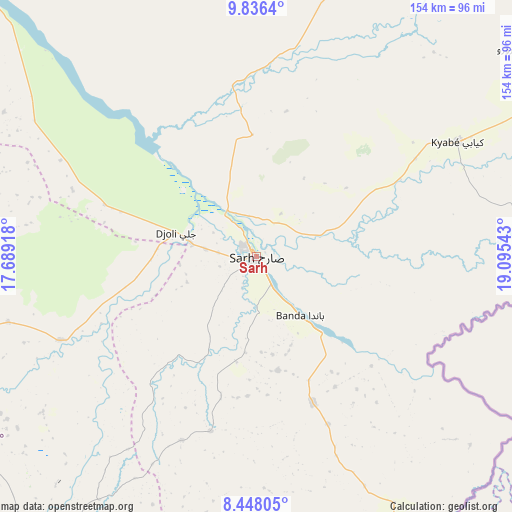
Sarh GPS coordinates[2]
9° 8' 34.44" North, 18° 23' 32.28" East
| Map corner | latitude | longitude |
|---|---|---|
| Upper-left | 9.8364°, | 17.68918° |
| Center: | 9.1429°, | 18.3923° |
| Lower-right: | 8.44805°, | 19.09543° |
| Map W x H: | 154.4×154.4 km | = 95.9×95.9mi |
| max Lat: | 21.8375° ⇑83% North |
| Sarh: | 9.1429° |
| min Lat: | ⇓17% South 8.26681° |
| min Long | Sarh | max Long |
| 14.1539° | 18.3923° | 22.84308° |
| W 72.3%⇐ | ⇒27.7% E |
Elevation
Elevation of Sarh is 369 m = 1211 ft, and this is 68.3 m = 224 ft below average elevation for this country.
| Max E: |
1046 m = 3432 ft | 57.4% |
| Avg. | 437.3 m = 1435 ft | |
| Sarh | 369 m = 1211 ft | |
Min E: |
242 m = 794 ft | 42.6% |
See also: Sarh elevation on elevation.city.
Geographical zone
Sarh is located in North Torrid zone (between Equator and Tropic of Cancer). Distance of Equator is 1016.6 km =631.7 mi to South.| Distance of | km | miles | from Sarh |
|---|---|---|---|
| North Pole | 8990.5 | 5586.4 | to North |
| Arctic Circle | 6384.6 | 3967.2 | to North |
| Tropic Cancer | 1589.3 | 987.5 | to North |
| Equator | 1016.6 | 631.7 | to South |


Nearby cities:
15 places around Sarh: (largest is in red/bold)
• Am Timan
294.7 km =183.1 mi,  44°
44°
• Benoy
228.2 km =141.8 mi,  265°
265°
• Bousso
237.1 km =147.3 mi,  309°
309°
• Béboto
187.1 km =116.3 mi,  238°
238°
• Bébédja
207.2 km =128.7 mi,  255°
255°
• Béré
246.3 km =153 mi, 274°
• Doba
178.1 km =110.7 mi,  252°
252°
• Goundi
115.3 km =71.6 mi,  282°
282°
• Kelo
284.4 km =176.7 mi, 273°
• Koumra
95.6 km =59.4 mi, 254°
• Kyabé
69.7 km =43.3 mi,  60°
60°
• Laï
231.3 km =143.7 mi, 277°
• Melfi
218.9 km =136 mi,  346°
346°
• Moundou
261.6 km =162.6 mi, 255°
• Moïssala
112.7 km =70 mi,  217°
217°
Sources, notices
• [Note1] Compared only with cities in Chad existing in our database
• [Src1] Map data: © OpenStreetMap contributors (CC-BY-SA)
• [Src2] Other city data from geonames.org with taken over terms of usage.
• [Src3] Geographical zone / Annual Mean Temperature by Robert A. Rohde @ Wikipedia
