Navgarzan geodata
Navgarzan (Sughd) is a populated place; located in Tajikistan in Asia/Dushanbe (GMT+5) time zone. With population of 877 people, there are 64 cities with bigger population in this country. Compared to other cities in Tajikistan, 100% of cities are located further ↓South; 80.7% of cities are located further ←West and 88.6% of cities have lower elevation than Navgarzan. Note1


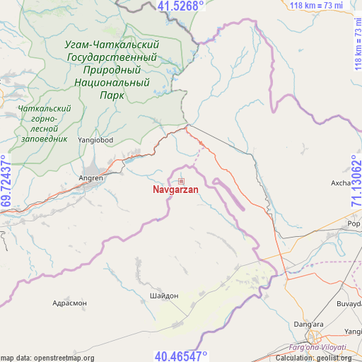
Navgarzan GPS coordinates[2]
40° 59' 53.772" North, 70° 25' 38.964" East
| Map corner | latitude | longitude |
|---|---|---|
| Upper-left | 41.5268°, | 69.72437° |
| Center: | 40.99827°, | 70.42749° |
| Lower-right: | 40.46547°, | 71.13062° |
| Map W x H: | 118×118 km | = 73.3×73.3mi |
| max Lat: | 40.99827° ⇑0% North |
| Navgarzan: | 40.99827° |
| min Lat: | ⇓100% South 36.72484° |
| min Long | Navgarzan | max Long |
| 67.60931° | 70.42749° | 73.96674° |
| W 80.7%⇐ | ⇒19.3% E |
Elevation
Elevation of Navgarzan is 1753 m = 5751 ft, and this is 790.5 m = 2594 ft above average elevation for this country.
| Max E: |
3607 m = 11834 ft | 11.4% |
| Navgarzan | 1753 m 5751 ft | |
| Avg. | 962.5 m = 3158 ft | |
Min E: |
324 m = 1063 ft | 88.6% |
See also: Tajikistan elevation on elevation.city.
Geographical zone
Navgarzan is located in North temperate zone (between Tropic of Cancer and the Arctic Circle). Distance of this Northern Tropic circle is 1952.7 km =1213.4 mi to South.| Distance of | km | miles | from Navgarzan |
|---|---|---|---|
| North Pole | 5448.5 | 3385.5 | to North |
| Arctic Circle | 2842.6 | 1766.3 | to North |
| Tropic Cancer | 1952.7 | 1213.4 | to South |
| Equator | 4558.6 | 2832.6 | to South |


Nearby cities:
15 places around Navgarzan: (largest is in red/bold)
• Adrasmon
53.8 km =33.4 mi,  223°
223°
• Chkalov
105.1 km =65.3 mi, 216°
• Ghafurov
105.1 km =65.3 mi,  214°
214°
• Isfara
98.4 km =61.1 mi,  170°
170°
• Khŭjand
104.6 km =65 mi, 220°
• Kim
87.9 km =54.6 mi,  177°
177°
• Konibodom
78.3 km =48.7 mi, 179°
• Konsoy
83.1 km =51.6 mi,  227°
227°
• Neftobod
87.9 km =54.6 mi, 172°
• Oltintopkan
79.6 km =49.5 mi,  241°
241°
• Palos
95.6 km =59.4 mi, 217°
• Quruqsoy
99.9 km =62.1 mi, 242°
• Shaydon
37.1 km =23.1 mi,  190°
190°
• Shŭrob
106.3 km =66.1 mi, 174°
• Taboshar
81.5 km =50.6 mi, 234°
Sources, notices
• [Note1] Compared only with cities in Tajikistan existing in our database
• [Src1] Map data: © OpenStreetMap contributors (CC-BY-SA)
• [Src2] Other city data from geonames.org with taken over terms of usage.
• [Src3] Geographical zone / Annual Mean Temperature by Robert A. Rohde @ Wikipedia
