Pishchanka geodata
Pishchanka (Vinnyts'ka) is a seat of a second-order administrative division; located in Ukraine in Europe/Kiev (GMT+3) time zone. In our database, there are 1661 cities with bigger population. Compared to other cities in Ukraine, 52.2% of cities are located further ↑North; 72.9% of cities are located further →East and 75.7% of cities have lower elevation than Pishchanka. Note1


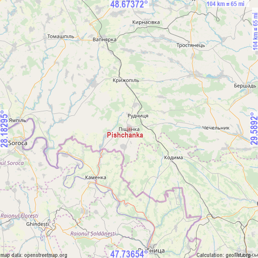
Pishchanka GPS coordinates[2]
48° 12' 26.172" North, 28° 53' 9.852" East
| Map corner | latitude | longitude |
|---|---|---|
| Upper-left | 48.67372°, | 28.18295° |
| Center: | 48.20727°, | 28.88607° |
| Lower-right: | 47.73654°, | 29.5892° |
| Map W x H: | 104.2×104.2 km | = 64.7×64.7mi |
| max Lat: | 52.18903° ⇑52.2% North |
| Pishchanka: | 48.20727° |
| min Lat: | ⇓47.8% South 44.39214° |
| min Long | Pishchanka | max Long |
| 22.20555° | 28.88607° | 40.13222° |
| W 27.1%⇐ | ⇒72.9% E |
Elevation
Elevation of Pishchanka is 228 m = 748 ft, and this is 72.2 m = 237 ft above average elevation for this country.
| Max E: |
886 m = 2907 ft | 24.3% |
| Pishchanka | 228 m 748 ft | |
| Avg. | 155.8 m = 511 ft | |
Min E: |
-3 m = -10 ft | 75.7% |
See also: Ukraine elevation on elevation.city.
Geographical zone
Pishchanka is located in North temperate zone (between Tropic of Cancer and the Arctic Circle). Distance of this North polar circle is 2041 km =1268.2 mi to North.| Distance of | km | miles | from Pishchanka |
|---|---|---|---|
| North Pole | 4646.9 | 2887.4 | to North |
| Arctic Circle | 2041 | 1268.2 | to North |
| Tropic Cancer | 2754.2 | 1711.4 | to South |
| Equator | 5360.1 | 3330.6 | to South |


Nearby cities:
15 places around Pishchanka: (largest is in red/bold)
• Bershad
50 km =31.1 mi,  69°
69°
• Chechelnyk
35.7 km =22.2 mi,  88°
88°
• Klembivka
40.6 km =25.2 mi,  300°
300°
• Kodyma
21.4 km =13.3 mi,  124°
124°
• Kryzhopil’
19.6 km =12.2 mi,  355°
355°
• Obodivka
34.6 km =21.5 mi,  50°
50°
• Slobidka
49.4 km =30.7 mi,  136°
136°
• Tomashpil’
46.2 km =28.7 mi,  323°
323°
• Torkanivka
23.3 km =14.5 mi,  56°
56°
• Trostyanets’
42.4 km =26.3 mi,  37°
37°
• Tsybulevka
25.6 km =15.9 mi, 38°
• Tulchyn
52 km =32.3 mi, 356°
• Vapnyarka
37.9 km =23.5 mi,  343°
343°
• Yampil’
44.9 km =27.9 mi,  274°
274°
• Zagnitkiv
17.6 km =10.9 mi,  178°
178°
Sources, notices
• [Note1] Compared only with cities in Ukraine existing in our database
• [Src1] Map data: © OpenStreetMap contributors (CC-BY-SA)
• [Src2] Other city data from geonames.org with taken over terms of usage.
• [Src3] Geographical zone / Annual Mean Temperature by Robert A. Rohde @ Wikipedia
