Zagnitkiv geodata
Zagnitkiv (Odesa) is a populated place; located in Ukraine in Europe/Kiev (GMT+3) time zone. With population of 4,000 people, there are 762 cities with bigger population in this country. Compared to other cities in Ukraine, 55.8% of cities are located further ↑North; 72.8% of cities are located further →East and 74.3% of cities have lower elevation than Zagnitkiv. Note1


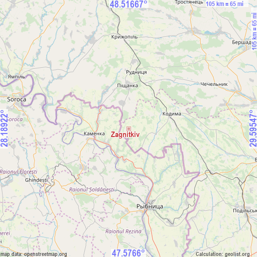
Zagnitkiv GPS coordinates[2]
48° 2' 55.608" North, 28° 53' 32.424" East
| Map corner | latitude | longitude |
|---|---|---|
| Upper-left | 48.51667°, | 28.18922° |
| Center: | 48.04878°, | 28.89234° |
| Lower-right: | 47.5766°, | 29.59547° |
| Map W x H: | 104.5×104.5 km | = 64.9×64.9mi |
| max Lat: | 52.18903° ⇑55.8% North |
| Zagnitkiv: | 48.04878° |
| min Lat: | ⇓44.2% South 44.39214° |
| min Long | Zagnitkiv | max Long |
| 22.20555° | 28.89234° | 40.13222° |
| W 27.2%⇐ | ⇒72.8% E |
Elevation
Elevation of Zagnitkiv is 222 m = 728 ft, and this is 66.2 m = 217 ft above average elevation for this country.
| Max E: |
886 m = 2907 ft | 25.7% |
| Zagnitkiv | 222 m 728 ft | |
| Avg. | 155.8 m = 511 ft | |
Min E: |
-3 m = -10 ft | 74.3% |
See also: Ukraine elevation on elevation.city.
Geographical zone
Zagnitkiv is located in North temperate zone (between Tropic of Cancer and the Arctic Circle). Distance of this North polar circle is 2058.7 km =1279.2 mi to North.| Distance of | km | miles | from Zagnitkiv |
|---|---|---|---|
| North Pole | 4664.5 | 2898.4 | to North |
| Arctic Circle | 2058.7 | 1279.2 | to North |
| Tropic Cancer | 2736.6 | 1700.4 | to South |
| Equator | 5342.5 | 3319.7 | to South |


Nearby cities:
15 places around Zagnitkiv: (largest is in red/bold)
• Balta
55.6 km =34.5 mi,  103°
103°
• Bershad
58.3 km =36.2 mi,  52°
52°
• Chechelnyk
39.8 km =24.7 mi,  62°
62°
• Klembivka
52.1 km =32.4 mi,  316°
316°
• Kodyma
18.1 km =11.2 mi,  72°
72°
• Kryzhopil’
37.2 km =23.1 mi,  357°
357°
• Obodivka
47.6 km =29.6 mi,  33°
33°
• Pishchanka
17.6 km =10.9 mi, 358°
• Podil’s’k
57.9 km =36 mi,  124°
124°
• Slobidka
38.3 km =23.8 mi, 118°
• Torkanivka
36 km =22.4 mi, 31°
• Trostyanets’
57.2 km =35.5 mi, 26°
• Tsybulevka
40.7 km =25.3 mi,  22°
22°
• Vapnyarka
55.1 km =34.2 mi,  348°
348°
• Yampil’
50.1 km =31.1 mi,  295°
295°
Sources, notices
• [Note1] Compared only with cities in Ukraine existing in our database
• [Src1] Map data: © OpenStreetMap contributors (CC-BY-SA)
• [Src2] Other city data from geonames.org with taken over terms of usage.
• [Src3] Geographical zone / Annual Mean Temperature by Robert A. Rohde @ Wikipedia
