Victoria Falls geodata
Victoria Falls (Matabeleland North) is a populated place; located in Zimbabwe in Africa/Harare (GMT+2) time zone. With population of 35,761 people, there are 15 cities with bigger population in this country. Compared to other cities in Zimbabwe, 64.6% of cities are located further ↓South; 100% of cities are located further →East and 84.6% of cities have higher elevation than Victoria Falls. Note1


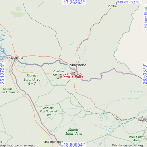
Victoria Falls GPS coordinates[2]
17° 55' 58.26" South, 25° 49' 50.376" East
| Map corner | latitude | longitude |
|---|---|---|
| Upper-left | -17.26263°, | 25.12754° |
| Center: | -17.93285°, | 25.83066° |
| Lower-right: | -18.60054°, | 26.53379° |
| Map W x H: | 148.8×148.8 km | = 92.5×92.5mi |
| max Lat: | -16.03333° ⇑35.4% North |
| Victoria Falls: | -17.93285° |
| min Lat: | ⇓64.6% South -22.21667° |
| min Long | Victoria Falls | max Long |
| 25.83066° | 25.83066° | 32.86667° |
| W 0%⇐ | ⇒100% E |
Elevation
Elevation of Victoria Falls is 961 m = 3153 ft, and this is 236.7 m = 777 ft below average elevation for this country.
| Max E: |
1706 m = 5597 ft | 84.6% |
| Avg. | 1197.7 m = 3929 ft | |
| Victoria Falls | 961 m = 3153 ft | |
Min E: |
402 m = 1319 ft | 15.4% |
See also: Zimbabwe elevation on elevation.city.
Geographical zone
Victoria Falls is located in South Torrid zone (between Equator and Tropic of Capricorn). Distance of this Southern Tropic circle is 612 km =380.3 mi to South.| Distance of | km | miles | from Victoria Falls |
|---|---|---|---|
| Equator | 1993.9 | 1239 | to North |
| Tropic Capricorn | 612 | 380.3 | to South |
| Antarctic Circle | 5407.2 | 3359.9 | to South |
| South Pole | 8013.1 | 4979.1 | to South |


Nearby cities:
14 places around Victoria Falls: (largest is in red/bold)
• Binga
163.7 km =101.7 mi,  77°
77°
• Bulawayo
380.1 km =236.2 mi,  130°
130°
• Chirundu
384.3 km =238.8 mi,  56°
56°
• Dete
133.2 km =82.8 mi,  124°
124°
• Esigodini
417.3 km =259.3 mi, 128°
• Gokwe
329.5 km =204.7 mi,  95°
95°
• Hwange
85.4 km =53.1 mi, 124°
• Insiza
409.9 km =254.7 mi, 120°
• Inyati
371.9 km =231.1 mi, 121°
• Kamativi Mine
136.4 km =84.8 mi,  108°
108°
• Kariba
352.5 km =219 mi, 63°
• Lupane
236.2 km =146.8 mi, 118°
• Plumtree
352 km =218.7 mi,  143°
143°
• Shangani
425.1 km =264.1 mi, 118°
Sources, notices
• [Note1] Compared only with cities in Zimbabwe existing in our database
• [Src1] Map data: © OpenStreetMap contributors (CC-BY-SA)
• [Src2] Other city data from geonames.org with taken over terms of usage.
• [Src3] Geographical zone / Annual Mean Temperature by Robert A. Rohde @ Wikipedia
