Hwange geodata
Hwange (Matabeleland North) is a populated place; located in Zimbabwe in Africa/Harare (GMT+2) time zone. With population of 33,210 people, there are 16 cities with bigger population in this country. Compared to other cities in Zimbabwe, 53.8% of cities are located further ↑North; 98.5% of cities are located further →East and 92.3% of cities have higher elevation than Hwange. Note1


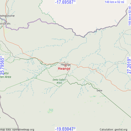
Hwange GPS coordinates[2]
18° 21' 52.056" South, 26° 29' 55.572" East
| Map corner | latitude | longitude |
|---|---|---|
| Upper-left | -17.69587°, | 25.79565° |
| Center: | -18.36446°, | 26.49877° |
| Lower-right: | -19.03047°, | 27.2019° |
| Map W x H: | 148.4×148.4 km | = 92.2×92.2mi |
| max Lat: | -16.03333° ⇑53.8% North |
| Hwange: | -18.36446° |
| min Lat: | ⇓46.2% South -22.21667° |
| min Long | Hwange | max Long |
| 25.83066° | 26.49877° | 32.86667° |
| W 1.5%⇐ | ⇒98.5% E |
Elevation
Elevation of Hwange is 767 m = 2516 ft, and this is 430.7 m = 1413 ft below average elevation for this country.
| Max E: |
1706 m = 5597 ft | 92.3% |
| Avg. | 1197.7 m = 3929 ft | |
| Hwange | 767 m = 2516 ft | |
Min E: |
402 m = 1319 ft | 7.7% |
See also: Zimbabwe elevation on elevation.city.
Geographical zone
Hwange is located in South Torrid zone (between Equator and Tropic of Capricorn). Distance of this Southern Tropic circle is 564 km =350.5 mi to South.| Distance of | km | miles | from Hwange |
|---|---|---|---|
| Equator | 2041.9 | 1268.8 | to North |
| Tropic Capricorn | 564 | 350.5 | to South |
| Antarctic Circle | 5359.2 | 3330.1 | to South |
| South Pole | 7965.1 | 4949.3 | to South |


Nearby cities:
15 places around Hwange: (largest is in red/bold)
• Binga
121.6 km =75.6 mi,  47°
47°
• Bulawayo
295.4 km =183.6 mi,  132°
132°
• Dete
47.9 km =29.8 mi, 125°
• Esigodini
332.4 km =206.5 mi, 130°
• Gokwe
257.8 km =160.2 mi,  86°
86°
• Insiza
324.7 km =201.8 mi,  119°
119°
• Inyati
286.7 km =178.1 mi, 120°
• Kamativi Mine
59.2 km =36.8 mi,  84°
84°
• Kariba
319.1 km =198.3 mi, 49°
• Kwekwe
354.9 km =220.5 mi,  100°
100°
• Lupane
151.6 km =94.2 mi,  114°
114°
• Plumtree
273.1 km =169.7 mi,  149°
149°
• Redcliff
353.8 km =219.8 mi, 102°
• Shangani
340.2 km =211.4 mi, 117°
• Victoria Falls
85.4 km =53.1 mi,  304°
304°
Sources, notices
• [Note1] Compared only with cities in Zimbabwe existing in our database
• [Src1] Map data: © OpenStreetMap contributors (CC-BY-SA)
• [Src2] Other city data from geonames.org with taken over terms of usage.
• [Src3] Geographical zone / Annual Mean Temperature by Robert A. Rohde @ Wikipedia
