Dete geodata
Dete (Matabeleland North) is a populated place; located in Zimbabwe in Africa/Harare (GMT+2) time zone. With population of 2,993 people, there are 50 cities with bigger population in this country. Compared to other cities in Zimbabwe, 56.9% of cities are located further ↑North; 96.9% of cities are located further →East and 67.7% of cities have higher elevation than Dete. Note1


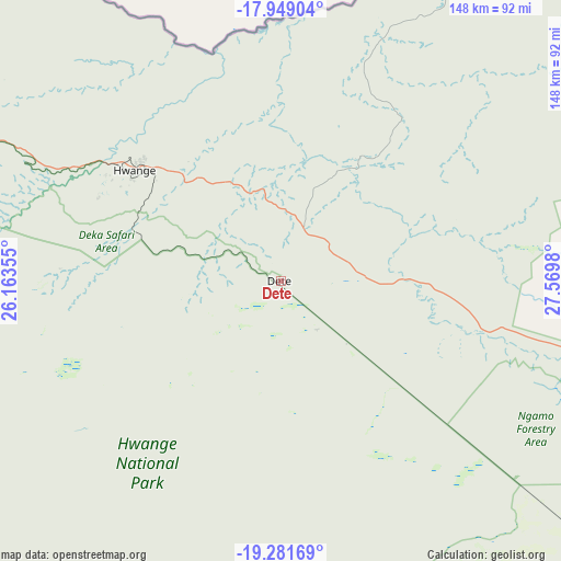
Dete GPS coordinates[2]
18° 37' 0.012" South, 26° 52' 0.012" East
| Map corner | latitude | longitude |
|---|---|---|
| Upper-left | -17.94904°, | 26.16355° |
| Center: | -18.61667°, | 26.86667° |
| Lower-right: | -19.28169°, | 27.5698° |
| Map W x H: | 148.2×148.2 km | = 92.1×92.1mi |
| max Lat: | -16.03333° ⇑56.9% North |
| Dete: | -18.61667° |
| min Lat: | ⇓43.1% South -22.21667° |
| min Long | Dete | max Long |
| 25.83066° | 26.86667° | 32.86667° |
| W 3.1%⇐ | ⇒96.9% E |
Elevation
Elevation of Dete is 1112 m = 3648 ft, and this is 85.7 m = 281 ft below average elevation for this country.
| Max E: |
1706 m = 5597 ft | 67.7% |
| Avg. | 1197.7 m = 3929 ft | |
| Dete | 1112 m = 3648 ft | |
Min E: |
402 m = 1319 ft | 32.3% |
See also: Zimbabwe elevation on elevation.city.
Geographical zone
Dete is located in South Torrid zone (between Equator and Tropic of Capricorn). Distance of this Southern Tropic circle is 535.9 km =333 mi to South.| Distance of | km | miles | from Dete |
|---|---|---|---|
| Equator | 2070 | 1286.2 | to North |
| Tropic Capricorn | 535.9 | 333 | to South |
| Antarctic Circle | 5331.2 | 3312.7 | to South |
| South Pole | 7937.1 | 4931.9 | to South |


Nearby cities:
15 places around Dete: (largest is in red/bold)
• Binga
121.6 km =75.6 mi,  24°
24°
• Bulawayo
248 km =154.1 mi,  133°
133°
• Esigodini
284.7 km =176.9 mi, 130°
• Gokwe
222.9 km =138.5 mi,  78°
78°
• Hwange
47.9 km =29.8 mi,  305°
305°
• Insiza
277.2 km =172.2 mi,  117°
117°
• Inyati
239 km =148.5 mi, 119°
• Kamativi Mine
39 km =24.2 mi,  30°
30°
• Kariba
310.7 km =193.1 mi,  41°
41°
• Kwekwe
312.3 km =194.1 mi,  96°
96°
• Lupane
105 km =65.2 mi,  109°
109°
• Plumtree
230.2 km =143 mi,  154°
154°
• Redcliff
310.4 km =192.9 mi, 98°
• Shangani
292.8 km =181.9 mi, 116°
• Victoria Falls
133.2 km =82.8 mi,  304°
304°
Sources, notices
• [Note1] Compared only with cities in Zimbabwe existing in our database
• [Src1] Map data: © OpenStreetMap contributors (CC-BY-SA)
• [Src2] Other city data from geonames.org with taken over terms of usage.
• [Src3] Geographical zone / Annual Mean Temperature by Robert A. Rohde @ Wikipedia
