Kariba geodata
Kariba (Mashonaland West) is a populated place; located in Zimbabwe in Africa/Harare (GMT+2) time zone. With population of 25,531 people, there are 22 cities with bigger population in this country. Compared to other cities in Zimbabwe, 98.5% of cities are located further ↓South; 87.7% of cities are located further →East and 93.8% of cities have higher elevation than Kariba. Note1


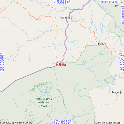
Kariba GPS coordinates[2]
16° 31' 0.012" South, 28° 48' 0" East
| Map corner | latitude | longitude |
|---|---|---|
| Upper-left | -15.8414°, | 28.09688° |
| Center: | -16.51667°, | 28.8° |
| Lower-right: | -17.18959°, | 29.50313° |
| Map W x H: | 149.9×149.9 km | = 93.1×93.1mi |
| max Lat: | -16.03333° ⇑1.5% North |
| Kariba: | -16.51667° |
| min Lat: | ⇓98.5% South -22.21667° |
| min Long | Kariba | max Long |
| 25.83066° | 28.8° | 32.86667° |
| W 12.3%⇐ | ⇒87.7% E |
Elevation
Elevation of Kariba is 679 m = 2228 ft, and this is 518.7 m = 1702 ft below average elevation for this country.
| Max E: |
1706 m = 5597 ft | 93.8% |
| Avg. | 1197.7 m = 3929 ft | |
| Kariba | 679 m = 2228 ft | |
Min E: |
402 m = 1319 ft | 6.2% |
See also: Zimbabwe elevation on elevation.city.
Geographical zone
Kariba is located in South Torrid zone (between Equator and Tropic of Capricorn). Distance of this Southern Tropic circle is 769.4 km =478.1 mi to South.| Distance of | km | miles | from Kariba |
|---|---|---|---|
| Equator | 1836.5 | 1141.1 | to North |
| Tropic Capricorn | 769.4 | 478.1 | to South |
| Antarctic Circle | 5564.7 | 3457.7 | to South |
| South Pole | 8170.6 | 5077 | to South |


Nearby cities:
15 places around Kariba: (largest is in red/bold)
• Banket
195.6 km =121.5 mi,  119°
119°
• Binga
197.7 km =122.8 mi,  231°
231°
• Centenary
247.7 km =153.9 mi,  95°
95°
• Chakari
207.4 km =128.9 mi,  145°
145°
• Chegutu
229 km =142.3 mi,  141°
141°
• Chinhoyi
176.4 km =109.6 mi, 122°
• Chirundu
54 km =33.6 mi,  5°
5°
• Concession
248.1 km =154.2 mi,  112°
112°
• Gokwe
188.2 km =116.9 mi,  175°
175°
• Kadoma
234.1 km =145.5 mi, 149°
• Karoi
100.5 km =62.4 mi, 108°
• Mhangura
151.6 km =94.2 mi, 106°
• Mvurwi
225.7 km =140.2 mi, 104°
• Norton
252.6 km =157 mi,  126°
126°
• Raffingora
183.1 km =113.8 mi, 108°
Sources, notices
• [Note1] Compared only with cities in Zimbabwe existing in our database
• [Src1] Map data: © OpenStreetMap contributors (CC-BY-SA)
• [Src2] Other city data from geonames.org with taken over terms of usage.
• [Src3] Geographical zone / Annual Mean Temperature by Robert A. Rohde @ Wikipedia
