Chivhu geodata
Chivhu (Mashonaland East) is a populated place; located in Zimbabwe in Africa/Harare (GMT+2) time zone. With population of 10,369 people, there are 29 cities with bigger population in this country. Compared to other cities in Zimbabwe, 67.7% of cities are located further ↑North; 58.5% of cities are located further ←West and 83.1% of cities have lower elevation than Chivhu. Note1


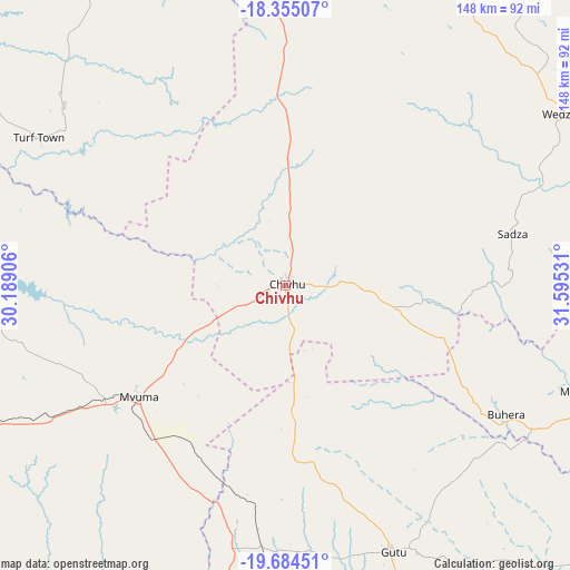
Chivhu GPS coordinates[2]
19° 1' 16.032" South, 30° 53' 31.848" East
| Map corner | latitude | longitude |
|---|---|---|
| Upper-left | -18.35507°, | 30.18906° |
| Center: | -19.02112°, | 30.89218° |
| Lower-right: | -19.68451°, | 31.59531° |
| Map W x H: | 147.8×147.8 km | = 91.8×91.8mi |
| max Lat: | -16.03333° ⇑67.7% North |
| Chivhu: | -19.02112° |
| min Lat: | ⇓32.3% South -22.21667° |
| min Long | Chivhu | max Long |
| 25.83066° | 30.89218° | 32.86667° |
| W 58.5%⇐ | ⇒41.5% E |
Elevation
Elevation of Chivhu is 1450 m = 4757 ft, and this is 252.3 m = 828 ft above average elevation for this country.
| Max E: |
1706 m = 5597 ft | 16.9% |
| Chivhu | 1450 m 4757 ft | |
| Avg. | 1197.7 m = 3929 ft | |
Min E: |
402 m = 1319 ft | 83.1% |
See also: Zimbabwe elevation on elevation.city.
Geographical zone
Chivhu is located in South Torrid zone (between Equator and Tropic of Capricorn). Distance of this Southern Tropic circle is 491 km =305.1 mi to South.| Distance of | km | miles | from Chivhu |
|---|---|---|---|
| Equator | 2115 | 1314.2 | to North |
| Tropic Capricorn | 491 | 305.1 | to South |
| Antarctic Circle | 5286.2 | 3284.7 | to South |
| South Pole | 7892.1 | 4903.9 | to South |


Nearby cities:
15 places around Chivhu: (largest is in red/bold)
• Beatrice
85.6 km =53.2 mi,  356°
356°
• Chegutu
126.8 km =78.8 mi,  321°
321°
• Chitungwiza
113.8 km =70.7 mi,  9°
9°
• Dorowa Mining Lease
90.3 km =56.1 mi,  93°
93°
• Gweru
122.6 km =76.2 mi,  247°
247°
• Kadoma
128.2 km =79.7 mi,  306°
306°
• Kwekwe
113.7 km =70.6 mi,  275°
275°
• Lalapanzi
82.6 km =51.3 mi, 245°
• Marondera
116.1 km =72.1 mi,  36°
36°
• Mashava
120.8 km =75.1 mi,  200°
200°
• Masvingo
116.1 km =72.1 mi,  183°
183°
• Mvuma
47.8 km =29.7 mi,  233°
233°
• Norton
128.1 km =79.6 mi,  350°
350°
• Redcliff
116.6 km =72.5 mi,  269°
269°
• Shurugwi
117.7 km =73.1 mi, 232°
Sources, notices
• [Note1] Compared only with cities in Zimbabwe existing in our database
• [Src1] Map data: © OpenStreetMap contributors (CC-BY-SA)
• [Src2] Other city data from geonames.org with taken over terms of usage.
• [Src3] Geographical zone / Annual Mean Temperature by Robert A. Rohde @ Wikipedia
