Shamva geodata
Shamva (Mashonaland Central) is a populated place; located in Zimbabwe in Africa/Harare (GMT+2) time zone. With population of 10,317 people, there are 30 cities with bigger population in this country. Compared to other cities in Zimbabwe, 84.6% of cities are located further ↓South; 76.9% of cities are located further ←West and 89.2% of cities have higher elevation than Shamva. Note1


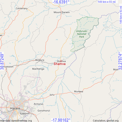
Shamva GPS coordinates[2]
17° 18' 41.724" South, 31° 34' 32.196" East
| Map corner | latitude | longitude |
|---|---|---|
| Upper-left | -16.6391°, | 30.87249° |
| Center: | -17.31159°, | 31.57561° |
| Lower-right: | -17.98162°, | 32.27874° |
| Map W x H: | 149.3×149.3 km | = 92.8×92.8mi |
| max Lat: | -16.03333° ⇑15.4% North |
| Shamva: | -17.31159° |
| min Lat: | ⇓84.6% South -22.21667° |
| min Long | Shamva | max Long |
| 25.83066° | 31.57561° | 32.86667° |
| W 76.9%⇐ | ⇒23.1% E |
Elevation
Elevation of Shamva is 947 m = 3107 ft, and this is 250.7 m = 823 ft below average elevation for this country.
| Max E: |
1706 m = 5597 ft | 89.2% |
| Avg. | 1197.7 m = 3929 ft | |
| Shamva | 947 m = 3107 ft | |
Min E: |
402 m = 1319 ft | 10.8% |
See also: Zimbabwe elevation on elevation.city.
Geographical zone
Shamva is located in South Torrid zone (between Equator and Tropic of Capricorn). Distance of this Southern Tropic circle is 681.1 km =423.2 mi to South.| Distance of | km | miles | from Shamva |
|---|---|---|---|
| Equator | 1924.9 | 1196.1 | to North |
| Tropic Capricorn | 681.1 | 423.2 | to South |
| Antarctic Circle | 5476.3 | 3402.8 | to South |
| South Pole | 8082.2 | 5022 | to South |


Nearby cities:
15 places around Shamva: (largest is in red/bold)
• Bindura
26 km =16.2 mi,  272°
272°
• Centenary
81.8 km =50.8 mi,  323°
323°
• Chitungwiza
94.3 km =58.6 mi,  214°
214°
• Concession
66.9 km =41.6 mi,  263°
263°
• Epworth
78.7 km =48.9 mi,  215°
215°
• Glendale
54.2 km =33.7 mi, 264°
• Harare
79.7 km =49.5 mi, 223°
• Macheke
96.5 km =60 mi,  162°
162°
• Madziwa
44.1 km =27.4 mi,  354°
354°
• Mazowe
67.3 km =41.8 mi,  251°
251°
• Mount Darwin
59.9 km =37.2 mi,  0°
0°
• Murehwa
43 km =26.7 mi,  149°
149°
• Mutoko
69.8 km =43.4 mi,  97°
97°
• Mvurwi
83.1 km =51.6 mi,  291°
291°
• Ruwa
73.2 km =45.5 mi, 208°
Sources, notices
• [Note1] Compared only with cities in Zimbabwe existing in our database
• [Src1] Map data: © OpenStreetMap contributors (CC-BY-SA)
• [Src2] Other city data from geonames.org with taken over terms of usage.
• [Src3] Geographical zone / Annual Mean Temperature by Robert A. Rohde @ Wikipedia
