Centenary geodata
Centenary (Mashonaland Central) is a populated place; located in Zimbabwe in Africa/Harare (GMT+2) time zone. With population of 3,388 people, there are 49 cities with bigger population in this country. Compared to other cities in Zimbabwe, 96.9% of cities are located further ↓South; 67.7% of cities are located further ←West and 53.8% of cities have higher elevation than Centenary. Note1


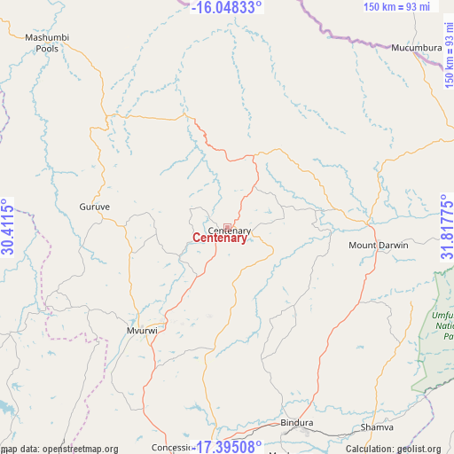
Centenary GPS coordinates[2]
16° 43' 22.404" South, 31° 6' 52.632" East
| Map corner | latitude | longitude |
|---|---|---|
| Upper-left | -16.04833°, | 30.4115° |
| Center: | -16.72289°, | 31.11462° |
| Lower-right: | -17.39508°, | 31.81775° |
| Map W x H: | 149.7×149.7 km | = 93×93mi |
| max Lat: | -16.03333° ⇑3.1% North |
| Centenary: | -16.72289° |
| min Lat: | ⇓96.9% South -22.21667° |
| min Long | Centenary | max Long |
| 25.83066° | 31.11462° | 32.86667° |
| W 67.7%⇐ | ⇒32.3% E |
Elevation
Elevation of Centenary is 1186 m = 3891 ft, and this is 11.7 m = 38 ft below average elevation for this country.
| Max E: |
1706 m = 5597 ft | 53.8% |
| Avg. | 1197.7 m = 3929 ft | |
| Centenary | 1186 m = 3891 ft | |
Min E: |
402 m = 1319 ft | 46.2% |
See also: Zimbabwe elevation on elevation.city.
Geographical zone
Centenary is located in South Torrid zone (between Equator and Tropic of Capricorn). Distance of this Southern Tropic circle is 746.5 km =463.9 mi to South.| Distance of | km | miles | from Centenary |
|---|---|---|---|
| Equator | 1859.4 | 1155.4 | to North |
| Tropic Capricorn | 746.5 | 463.9 | to South |
| Antarctic Circle | 5541.8 | 3443.5 | to South |
| South Pole | 8147.7 | 5062.7 | to South |


Nearby cities:
15 places around Centenary: (largest is in red/bold)
• Banket
105.7 km =65.7 mi,  225°
225°
• Bindura
68.4 km =42.5 mi,  160°
160°
• Chinhoyi
120.7 km =75 mi, 233°
• Concession
75.5 km =46.9 mi,  193°
193°
• Epworth
129.8 km =80.7 mi,  178°
178°
• Glendale
70.5 km =43.8 mi, 184°
• Harare
123 km =76.4 mi, 183°
• Madziwa
49.5 km =30.8 mi,  115°
115°
• Mazowe
88.1 km =54.7 mi, 189°
• Mhangura
102.5 km =63.7 mi,  259°
259°
• Mount Darwin
50.3 km =31.3 mi,  96°
96°
• Murehwa
124.6 km =77.4 mi,  145°
145°
• Mvurwi
44.5 km =27.7 mi,  219°
219°
• Raffingora
80.3 km =49.9 mi,  244°
244°
• Shamva
81.8 km =50.8 mi,  143°
143°
Sources, notices
• [Note1] Compared only with cities in Zimbabwe existing in our database
• [Src1] Map data: © OpenStreetMap contributors (CC-BY-SA)
• [Src2] Other city data from geonames.org with taken over terms of usage.
• [Src3] Geographical zone / Annual Mean Temperature by Robert A. Rohde @ Wikipedia
