Madziwa geodata
Madziwa (Mashonaland Central) is a populated place; located in Zimbabwe in Africa/Harare (GMT+2) time zone. With population of 527 people, there are 65 cities with bigger population in this country. Compared to other cities in Zimbabwe, 90.8% of cities are located further ↓South; 73.8% of cities are located further ←West and 75.4% of cities have higher elevation than Madziwa. Note1


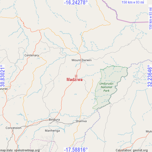
Madziwa GPS coordinates[2]
16° 55' 0.012" South, 31° 31' 59.988" East
| Map corner | latitude | longitude |
|---|---|---|
| Upper-left | -16.24278°, | 30.83021° |
| Center: | -16.91667°, | 31.53333° |
| Lower-right: | -17.58816°, | 32.23646° |
| Map W x H: | 149.6×149.6 km | = 93×93mi |
| max Lat: | -16.03333° ⇑9.2% North |
| Madziwa: | -16.91667° |
| min Lat: | ⇓90.8% South -22.21667° |
| min Long | Madziwa | max Long |
| 25.83066° | 31.53333° | 32.86667° |
| W 73.8%⇐ | ⇒26.2% E |
Elevation
Elevation of Madziwa is 1072 m = 3517 ft, and this is 125.7 m = 412 ft below average elevation for this country.
| Max E: |
1706 m = 5597 ft | 75.4% |
| Avg. | 1197.7 m = 3929 ft | |
| Madziwa | 1072 m = 3517 ft | |
Min E: |
402 m = 1319 ft | 24.6% |
See also: Zimbabwe elevation on elevation.city.
Geographical zone
Madziwa is located in South Torrid zone (between Equator and Tropic of Capricorn). Distance of this Southern Tropic circle is 725 km =450.5 mi to South.| Distance of | km | miles | from Madziwa |
|---|---|---|---|
| Equator | 1881 | 1168.8 | to North |
| Tropic Capricorn | 725 | 450.5 | to South |
| Antarctic Circle | 5520.2 | 3430.1 | to South |
| South Pole | 8126.1 | 5049.3 | to South |


Nearby cities:
15 places around Madziwa: (largest is in red/bold)
• Banket
131.1 km =81.5 mi,  246°
246°
• Bindura
48 km =29.8 mi,  206°
206°
• Centenary
49.5 km =30.8 mi,  295°
295°
• Concession
80.8 km =50.2 mi,  230°
230°
• Epworth
115.7 km =71.9 mi,  200°
200°
• Glendale
69.5 km =43.2 mi, 225°
• Harare
113.4 km =70.5 mi, 206°
• Mazowe
88.3 km =54.9 mi,  222°
222°
• Mount Darwin
16.9 km =10.5 mi,  18°
18°
• Murehwa
85.1 km =52.9 mi,  161°
161°
• Mutoko
91 km =56.5 mi,  125°
125°
• Mvurwi
73.8 km =45.9 mi,  259°
259°
• Raffingora
117.7 km =73.1 mi, 263°
• Ruwa
112.4 km =69.8 mi, 195°
• Shamva
44.1 km =27.4 mi,  174°
174°
Sources, notices
• [Note1] Compared only with cities in Zimbabwe existing in our database
• [Src1] Map data: © OpenStreetMap contributors (CC-BY-SA)
• [Src2] Other city data from geonames.org with taken over terms of usage.
• [Src3] Geographical zone / Annual Mean Temperature by Robert A. Rohde @ Wikipedia
