Glendale geodata
Glendale (Mashonaland Central) is a populated place; located in Zimbabwe in Africa/Harare (GMT+2) time zone. With population of 9,768 people, there are 32 cities with bigger population in this country. Compared to other cities in Zimbabwe, 83.1% of cities are located further ↓South; 64.6% of cities are located further ←West and 63.1% of cities have higher elevation than Glendale. Note1


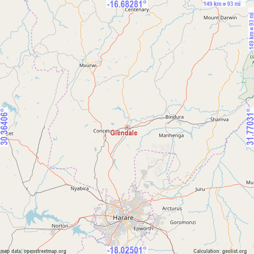
Glendale GPS coordinates[2]
17° 21' 18.504" South, 31° 4' 1.848" East
| Map corner | latitude | longitude |
|---|---|---|
| Upper-left | -16.68281°, | 30.36406° |
| Center: | -17.35514°, | 31.06718° |
| Lower-right: | -18.02501°, | 31.77031° |
| Map W x H: | 149.2×149.2 km | = 92.7×92.7mi |
| max Lat: | -16.03333° ⇑16.9% North |
| Glendale: | -17.35514° |
| min Lat: | ⇓83.1% South -22.21667° |
| min Long | Glendale | max Long |
| 25.83066° | 31.06718° | 32.86667° |
| W 64.6%⇐ | ⇒35.4% E |
Elevation
Elevation of Glendale is 1143 m = 3750 ft, and this is 54.7 m = 179 ft below average elevation for this country.
| Max E: |
1706 m = 5597 ft | 63.1% |
| Avg. | 1197.7 m = 3929 ft | |
| Glendale | 1143 m = 3750 ft | |
Min E: |
402 m = 1319 ft | 36.9% |
See also: Zimbabwe elevation on elevation.city.
Geographical zone
Glendale is located in South Torrid zone (between Equator and Tropic of Capricorn). Distance of this Southern Tropic circle is 676.2 km =420.2 mi to South.| Distance of | km | miles | from Glendale |
|---|---|---|---|
| Equator | 1929.7 | 1199.1 | to North |
| Tropic Capricorn | 676.2 | 420.2 | to South |
| Antarctic Circle | 5471.5 | 3399.8 | to South |
| South Pole | 8077.4 | 5019.1 | to South |


Nearby cities:
15 places around Glendale: (largest is in red/bold)
• Banket
70.9 km =44.1 mi,  267°
267°
• Bindura
28.6 km =17.8 mi,  78°
78°
• Centenary
70.5 km =43.8 mi,  4°
4°
• Chitungwiza
73.1 km =45.4 mi,  179°
179°
• Concession
12.8 km =8 mi,  255°
255°
• Epworth
60.1 km =37.3 mi,  171°
171°
• Harare
52.6 km =32.7 mi, 181°
• Madziwa
69.5 km =43.2 mi,  45°
45°
• Mazowe
19.3 km =12 mi,  210°
210°
• Murehwa
82.5 km =51.3 mi,  112°
112°
• Mvurwi
42.6 km =26.5 mi,  327°
327°
• Norton
70.4 km =43.7 mi, 213°
• Raffingora
76.2 km =47.3 mi,  297°
297°
• Ruwa
62.3 km =38.7 mi,  162°
162°
• Shamva
54.2 km =33.7 mi, 84°
Sources, notices
• [Note1] Compared only with cities in Zimbabwe existing in our database
• [Src1] Map data: © OpenStreetMap contributors (CC-BY-SA)
• [Src2] Other city data from geonames.org with taken over terms of usage.
• [Src3] Geographical zone / Annual Mean Temperature by Robert A. Rohde @ Wikipedia
