Bindura geodata
Bindura (Mashonaland Central) is a seat of a first-order administrative division; located in Zimbabwe in Africa/Harare (GMT+2) time zone. With population of 37,423 people, there are 13 cities with bigger population in this country. Compared to other cities in Zimbabwe, 86.2% of cities are located further ↓South; 72.3% of cities are located further ←West and 64.6% of cities have higher elevation than Bindura. Note1


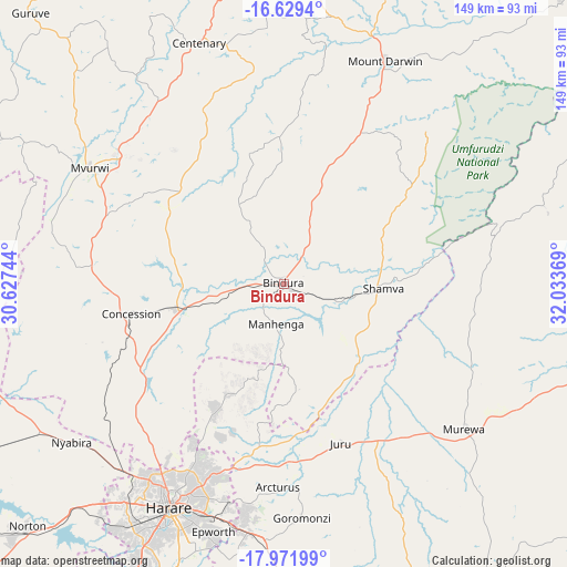
Bindura GPS coordinates[2]
17° 18' 6.912" South, 31° 19' 50.016" East
| Map corner | latitude | longitude |
|---|---|---|
| Upper-left | -16.6294°, | 30.62744° |
| Center: | -17.30192°, | 31.33056° |
| Lower-right: | -17.97199°, | 32.03369° |
| Map W x H: | 149.3×149.3 km | = 92.8×92.8mi |
| max Lat: | -16.03333° ⇑13.8% North |
| Bindura: | -17.30192° |
| min Lat: | ⇓86.2% South -22.21667° |
| min Long | Bindura | max Long |
| 25.83066° | 31.33056° | 32.86667° |
| W 72.3%⇐ | ⇒27.7% E |
Elevation
Elevation of Bindura is 1118 m = 3668 ft, and this is 79.7 m = 261 ft below average elevation for this country.
| Max E: |
1706 m = 5597 ft | 64.6% |
| Avg. | 1197.7 m = 3929 ft | |
| Bindura | 1118 m = 3668 ft | |
Min E: |
402 m = 1319 ft | 35.4% |
See also: Zimbabwe elevation on elevation.city.
Geographical zone
Bindura is located in South Torrid zone (between Equator and Tropic of Capricorn). Distance of this Southern Tropic circle is 682.1 km =423.8 mi to South.| Distance of | km | miles | from Bindura |
|---|---|---|---|
| Equator | 1923.8 | 1195.4 | to North |
| Tropic Capricorn | 682.1 | 423.8 | to South |
| Antarctic Circle | 5477.4 | 3403.5 | to South |
| South Pole | 8083.3 | 5022.7 | to South |


Nearby cities:
15 places around Bindura: (largest is in red/bold)
• Centenary
68.4 km =42.5 mi,  340°
340°
• Chitungwiza
83.5 km =51.9 mi,  198°
198°
• Concession
41.4 km =25.7 mi,  257°
257°
• Epworth
68.2 km =42.4 mi, 196°
• Glendale
28.6 km =17.8 mi, 258°
• Harare
65.4 km =40.6 mi,  206°
206°
• Madziwa
48 km =29.8 mi,  26°
26°
• Mazowe
44 km =27.3 mi,  239°
239°
• Mount Darwin
64.7 km =40.2 mi,  24°
24°
• Murehwa
61.3 km =38.1 mi,  128°
128°
• Mutoko
95.7 km =59.5 mi,  96°
96°
• Mvurwi
59.1 km =36.7 mi,  300°
300°
• Norton
93 km =57.8 mi,  225°
225°
• Ruwa
66 km =41 mi,  187°
187°
• Shamva
26 km =16.2 mi,  92°
92°
Sources, notices
• [Note1] Compared only with cities in Zimbabwe existing in our database
• [Src1] Map data: © OpenStreetMap contributors (CC-BY-SA)
• [Src2] Other city data from geonames.org with taken over terms of usage.
• [Src3] Geographical zone / Annual Mean Temperature by Robert A. Rohde @ Wikipedia
