Mutoko geodata
Mutoko (Mashonaland East) is a populated place; located in Zimbabwe in Africa/Harare (GMT+2) time zone. With population of 9,532 people, there are 34 cities with bigger population in this country. Compared to other cities in Zimbabwe, 76.9% of cities are located further ↓South; 90.8% of cities are located further ←West and 60% of cities have lower elevation than Mutoko. Note1


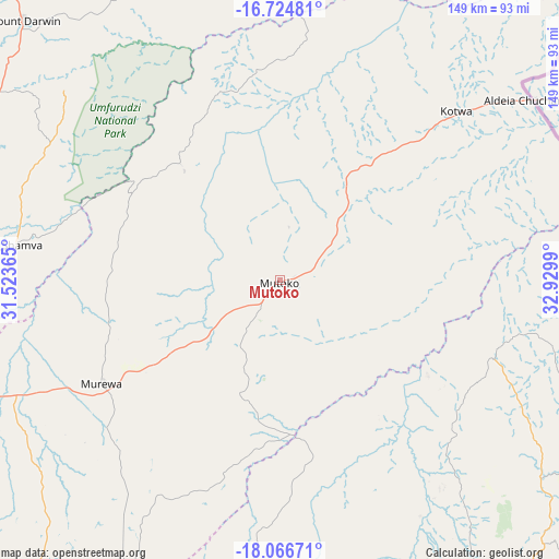
Mutoko GPS coordinates[2]
17° 23' 49.164" South, 32° 13' 36.372" East
| Map corner | latitude | longitude |
|---|---|---|
| Upper-left | -16.72481°, | 31.52365° |
| Center: | -17.39699°, | 32.22677° |
| Lower-right: | -18.06671°, | 32.9299° |
| Map W x H: | 149.2×149.2 km | = 92.7×92.7mi |
| max Lat: | -16.03333° ⇑23.1% North |
| Mutoko: | -17.39699° |
| min Lat: | ⇓76.9% South -22.21667° |
| min Long | Mutoko | max Long |
| 25.83066° | 32.22677° | 32.86667° |
| W 90.8%⇐ | ⇒9.2% E |
Elevation
Elevation of Mutoko is 1285 m = 4216 ft, and this is 87.3 m = 286 ft above average elevation for this country.
| Max E: |
1706 m = 5597 ft | 40% |
| Mutoko | 1285 m 4216 ft | |
| Avg. | 1197.7 m = 3929 ft | |
Min E: |
402 m = 1319 ft | 60% |
See also: Zimbabwe elevation on elevation.city.
Geographical zone
Mutoko is located in South Torrid zone (between Equator and Tropic of Capricorn). Distance of this Southern Tropic circle is 671.6 km =417.3 mi to South.| Distance of | km | miles | from Mutoko |
|---|---|---|---|
| Equator | 1934.4 | 1202 | to North |
| Tropic Capricorn | 671.6 | 417.3 | to South |
| Antarctic Circle | 5466.8 | 3396.9 | to South |
| South Pole | 8072.7 | 5016.1 | to South |


Nearby cities:
15 places around Mutoko: (largest is in red/bold)
• Bindura
95.7 km =59.5 mi,  276°
276°
• Epworth
126.8 km =78.8 mi,  244°
244°
• Glendale
123.1 km =76.5 mi,  272°
272°
• Harare
133.3 km =82.8 mi,  248°
248°
• Headlands
99.6 km =61.9 mi,  190°
190°
• Macheke
91.7 km =57 mi,  205°
205°
• Madziwa
91 km =56.5 mi,  305°
305°
• Marondera
113.1 km =70.3 mi,  219°
219°
• Mazowe
133.4 km =82.9 mi,  264°
264°
• Mount Darwin
97.4 km =60.5 mi,  315°
315°
• Murehwa
54.3 km =33.7 mi, 239°
• Nyanga
106.7 km =66.3 mi,  148°
148°
• Rusape
126.2 km =78.4 mi,  184°
184°
• Ruwa
117.6 km =73.1 mi, 242°
• Shamva
69.8 km =43.4 mi, 277°
Sources, notices
• [Note1] Compared only with cities in Zimbabwe existing in our database
• [Src1] Map data: © OpenStreetMap contributors (CC-BY-SA)
• [Src2] Other city data from geonames.org with taken over terms of usage.
• [Src3] Geographical zone / Annual Mean Temperature by Robert A. Rohde @ Wikipedia
