Murehwa geodata
Murehwa (Mashonaland East) is a populated place; located in Zimbabwe in Africa/Harare (GMT+2) time zone. With population of 8,559 people, there are 35 cities with bigger population in this country. Compared to other cities in Zimbabwe, 72.3% of cities are located further ↓South; 83.1% of cities are located further ←West and 70.8% of cities have lower elevation than Murehwa. Note1


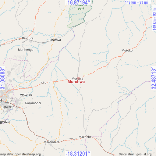
Murehwa GPS coordinates[2]
17° 38' 35.592" South, 31° 47' 2.4" East
| Map corner | latitude | longitude |
|---|---|---|
| Upper-left | -16.97194°, | 31.08088° |
| Center: | -17.64322°, | 31.784° |
| Lower-right: | -18.31201°, | 32.48713° |
| Map W x H: | 149×149 km | = 92.6×92.6mi |
| max Lat: | -16.03333° ⇑27.7% North |
| Murehwa: | -17.64322° |
| min Lat: | ⇓72.3% South -22.21667° |
| min Long | Murehwa | max Long |
| 25.83066° | 31.784° | 32.86667° |
| W 83.1%⇐ | ⇒16.9% E |
Elevation
Elevation of Murehwa is 1365 m = 4478 ft, and this is 167.3 m = 549 ft above average elevation for this country.
| Max E: |
1706 m = 5597 ft | 29.2% |
| Murehwa | 1365 m 4478 ft | |
| Avg. | 1197.7 m = 3929 ft | |
Min E: |
402 m = 1319 ft | 70.8% |
See also: Zimbabwe elevation on elevation.city.
Geographical zone
Murehwa is located in South Torrid zone (between Equator and Tropic of Capricorn). Distance of this Southern Tropic circle is 644.2 km =400.3 mi to South.| Distance of | km | miles | from Murehwa |
|---|---|---|---|
| Equator | 1961.7 | 1218.9 | to North |
| Tropic Capricorn | 644.2 | 400.3 | to South |
| Antarctic Circle | 5439.4 | 3379.9 | to South |
| South Pole | 8045.3 | 4999.1 | to South |


Nearby cities:
15 places around Murehwa: (largest is in red/bold)
• Bindura
61.3 km =38.1 mi,  308°
308°
• Chitungwiza
85.5 km =53.1 mi,  241°
241°
• Concession
93 km =57.8 mi,  288°
288°
• Epworth
72.8 km =45.2 mi,  247°
247°
• Glendale
82.5 km =51.3 mi, 292°
• Harare
80.1 km =49.8 mi,  255°
255°
• Headlands
76 km =47.2 mi,  158°
158°
• Macheke
55.6 km =34.5 mi,  172°
172°
• Madziwa
85.1 km =52.9 mi,  341°
341°
• Marondera
65.1 km =40.5 mi,  202°
202°
• Mazowe
87.3 km =54.2 mi,  280°
280°
• Mount Darwin
99.1 km =61.6 mi,  347°
347°
• Mutoko
54.3 km =33.7 mi,  59°
59°
• Ruwa
63.3 km =39.3 mi, 244°
• Shamva
43 km =26.7 mi,  329°
329°
Sources, notices
• [Note1] Compared only with cities in Zimbabwe existing in our database
• [Src1] Map data: © OpenStreetMap contributors (CC-BY-SA)
• [Src2] Other city data from geonames.org with taken over terms of usage.
• [Src3] Geographical zone / Annual Mean Temperature by Robert A. Rohde @ Wikipedia
