Mvurwi geodata
Mvurwi (Mashonaland Central) is a populated place; located in Zimbabwe in Africa/Harare (GMT+2) time zone. With population of 7,970 people, there are 37 cities with bigger population in this country. Compared to other cities in Zimbabwe, 87.7% of cities are located further ↓South; 56.9% of cities are located further ←West and 87.7% of cities have lower elevation than Mvurwi. Note1


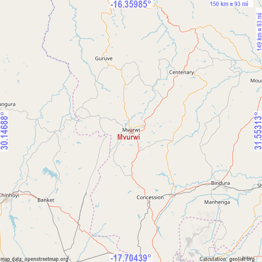
Mvurwi GPS coordinates[2]
17° 1' 59.988" South, 30° 51' 0" East
| Map corner | latitude | longitude |
|---|---|---|
| Upper-left | -16.35985°, | 30.14688° |
| Center: | -17.03333°, | 30.85° |
| Lower-right: | -17.70439°, | 31.55313° |
| Map W x H: | 149.5×149.5 km | = 92.9×92.9mi |
| max Lat: | -16.03333° ⇑12.3% North |
| Mvurwi: | -17.03333° |
| min Lat: | ⇓87.7% South -22.21667° |
| min Long | Mvurwi | max Long |
| 25.83066° | 30.85° | 32.86667° |
| W 56.9%⇐ | ⇒43.1% E |
Elevation
Elevation of Mvurwi is 1495 m = 4905 ft, and this is 297.3 m = 975 ft above average elevation for this country.
| Max E: |
1706 m = 5597 ft | 12.3% |
| Mvurwi | 1495 m 4905 ft | |
| Avg. | 1197.7 m = 3929 ft | |
Min E: |
402 m = 1319 ft | 87.7% |
See also: Zimbabwe elevation on elevation.city.
Geographical zone
Mvurwi is located in South Torrid zone (between Equator and Tropic of Capricorn). Distance of this Southern Tropic circle is 712 km =442.4 mi to South.| Distance of | km | miles | from Mvurwi |
|---|---|---|---|
| Equator | 1893.9 | 1176.8 | to North |
| Tropic Capricorn | 712 | 442.4 | to South |
| Antarctic Circle | 5507.2 | 3422 | to South |
| South Pole | 8113.1 | 5041.2 | to South |


Nearby cities:
15 places around Mvurwi: (largest is in red/bold)
• Banket
61.6 km =38.3 mi,  230°
230°
• Bindura
59.1 km =36.7 mi,  120°
120°
• Centenary
44.5 km =27.7 mi,  39°
39°
• Chinhoyi
78.4 km =48.7 mi,  241°
241°
• Concession
40.3 km =25 mi,  164°
164°
• Epworth
100.3 km =62.3 mi, 161°
• Glendale
42.6 km =26.5 mi,  147°
147°
• Harare
90.9 km =56.5 mi,  166°
166°
• Madziwa
73.8 km =45.9 mi,  79°
79°
• Mazowe
54 km =33.6 mi, 165°
• Mhangura
74.1 km =46 mi,  282°
282°
• Mount Darwin
83.3 km =51.8 mi,  69°
69°
• Norton
95.8 km =59.5 mi,  189°
189°
• Raffingora
44.3 km =27.5 mi,  270°
270°
• Shamva
83.1 km =51.6 mi,  111°
111°
Sources, notices
• [Note1] Compared only with cities in Zimbabwe existing in our database
• [Src1] Map data: © OpenStreetMap contributors (CC-BY-SA)
• [Src2] Other city data from geonames.org with taken over terms of usage.
• [Src3] Geographical zone / Annual Mean Temperature by Robert A. Rohde @ Wikipedia
