Marondera geodata
Marondera (Mashonaland East) is a seat of a first-order administrative division; located in Zimbabwe in Africa/Harare (GMT+2) time zone. With population of 57,082 people, there are 10 cities with bigger population in this country. Compared to other cities in Zimbabwe, 56.9% of cities are located further ↓South; 75.4% of cities are located further ←West and 98.5% of cities have lower elevation than Marondera. Note1


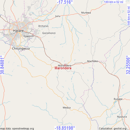
Marondera GPS coordinates[2]
18° 11' 6.972" South, 31° 33' 6.948" East
| Map corner | latitude | longitude |
|---|---|---|
| Upper-left | -17.516°, | 30.84881° |
| Center: | -18.18527°, | 31.55193° |
| Lower-right: | -18.85198°, | 32.25506° |
| Map W x H: | 148.5×148.6 km | = 92.3×92.3mi |
| max Lat: | -16.03333° ⇑43.1% North |
| Marondera: | -18.18527° |
| min Lat: | ⇓56.9% South -22.21667° |
| min Long | Marondera | max Long |
| 25.83066° | 31.55193° | 32.86667° |
| W 75.4%⇐ | ⇒24.6% E |
Elevation
Elevation of Marondera is 1668 m = 5472 ft, and this is 470.3 m = 1543 ft above average elevation for this country.
| Max E: |
1706 m = 5597 ft | 1.5% |
| Marondera | 1668 m 5472 ft | |
| Avg. | 1197.7 m = 3929 ft | |
Min E: |
402 m = 1319 ft | 98.5% |
See also: Marondera elevation on elevation.city.
Geographical zone
Marondera is located in South Torrid zone (between Equator and Tropic of Capricorn). Distance of this Southern Tropic circle is 583.9 km =362.8 mi to South.| Distance of | km | miles | from Marondera |
|---|---|---|---|
| Equator | 2022 | 1256.4 | to North |
| Tropic Capricorn | 583.9 | 362.8 | to South |
| Antarctic Circle | 5379.2 | 3342.5 | to South |
| South Pole | 7985 | 4961.6 | to South |


Nearby cities:
15 places around Marondera: (largest is in red/bold)
• Beatrice
74.8 km =46.5 mi,  264°
264°
• Bindura
101 km =62.8 mi,  346°
346°
• Chitungwiza
53.9 km =33.5 mi,  290°
290°
• Dorowa Mining Lease
100.2 km =62.3 mi,  167°
167°
• Epworth
53.9 km =33.5 mi,  307°
307°
• Harare
66 km =41 mi, 307°
• Headlands
53.7 km =33.4 mi,  100°
100°
• Macheke
31.8 km =19.8 mi,  80°
80°
• Mazowe
97.4 km =60.5 mi,  321°
321°
• Murehwa
65.1 km =40.5 mi,  22°
22°
• Norton
96.1 km =59.7 mi, 290°
• Nyazura
87 km =54.1 mi,  131°
131°
• Rusape
71.8 km =44.6 mi,  122°
122°
• Ruwa
46.2 km =28.7 mi, 315°
• Shamva
97.2 km =60.4 mi,  1°
1°
Sources, notices
• [Note1] Compared only with cities in Zimbabwe existing in our database
• [Src1] Map data: © OpenStreetMap contributors (CC-BY-SA)
• [Src2] Other city data from geonames.org with taken over terms of usage.
• [Src3] Geographical zone / Annual Mean Temperature by Robert A. Rohde @ Wikipedia
