Dorowa Mining Lease geodata
Dorowa Mining Lease (Manicaland) is a populated place; located in Zimbabwe in Africa/Harare (GMT+2) time zone. With population of 1,676 people, there are 60 cities with bigger population in this country. Compared to other cities in Zimbabwe, 70.8% of cities are located further ↑North; 81.5% of cities are located further ←West and 90.8% of cities have higher elevation than Dorowa Mining Lease. Note1


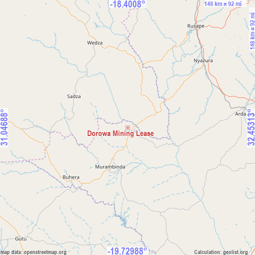
Dorowa Mining Lease GPS coordinates[2]
19° 4' 0.012" South, 31° 45' 0" East
| Map corner | latitude | longitude |
|---|---|---|
| Upper-left | -18.4008°, | 31.04688° |
| Center: | -19.06667°, | 31.75° |
| Lower-right: | -19.72988°, | 32.45313° |
| Map W x H: | 147.8×147.8 km | = 91.8×91.8mi |
| max Lat: | -16.03333° ⇑70.8% North |
| Dorowa Mining Lease: | -19.06667° |
| min Lat: | ⇓29.2% South -22.21667° |
| min Long | Dorowa Mining L | max Long |
| 25.83066° | 31.75° | 32.86667° |
| W 81.5%⇐ | ⇒18.5% E |
Elevation
Elevation of Dorowa Mining Lease is 916 m = 3005 ft, and this is 281.7 m = 924 ft below average elevation for this country.
| Max E: |
1706 m = 5597 ft | 90.8% |
| Avg. | 1197.7 m = 3929 ft | |
| Dorowa Mining Lease | 916 m = 3005 ft | |
Min E: |
402 m = 1319 ft | 9.2% |
See also: Zimbabwe elevation on elevation.city.
Geographical zone
Dorowa Mining Lease is located in South Torrid zone (between Equator and Tropic of Capricorn). Distance of this Southern Tropic circle is 485.9 km =301.9 mi to South.| Distance of | km | miles | from Dorowa Mining Lease |
|---|---|---|---|
| Equator | 2120 | 1317.3 | to North |
| Tropic Capricorn | 485.9 | 301.9 | to South |
| Antarctic Circle | 5281.2 | 3281.6 | to South |
| South Pole | 7887 | 4900.8 | to South |


Nearby cities:
15 places around Dorowa Mining Lease: (largest is in red/bold)
• Beatrice
131.3 km =81.6 mi,  313°
313°
• Chimanimani
142.7 km =88.7 mi,  124°
124°
• Chitungwiza
137.1 km =85.2 mi,  328°
328°
• Chivhu
90.3 km =56.1 mi,  273°
273°
• Headlands
93.3 km =58 mi,  19°
19°
• Macheke
103.7 km =64.4 mi,  5°
5°
• Marondera
100.2 km =62.3 mi,  347°
347°
• Mutare
97.4 km =60.5 mi,  83°
83°
• Mvuma
130.5 km =81.1 mi,  259°
259°
• Nyanga
141.5 km =87.9 mi,  48°
48°
• Nyazura
59.5 km =37 mi, 47°
• Odzi
69.9 km =43.4 mi, 80°
• Penhalonga
101.6 km =63.1 mi, 78°
• Rusape
71.9 km =44.7 mi,  33°
33°
• Ruwa
141.3 km =87.8 mi,  337°
337°
Sources, notices
• [Note1] Compared only with cities in Zimbabwe existing in our database
• [Src1] Map data: © OpenStreetMap contributors (CC-BY-SA)
• [Src2] Other city data from geonames.org with taken over terms of usage.
• [Src3] Geographical zone / Annual Mean Temperature by Robert A. Rohde @ Wikipedia
