Chipinge geodata
Chipinge (Manicaland) is a populated place; located in Zimbabwe in Africa/Harare (GMT+2) time zone. With population of 18,860 people, there are 25 cities with bigger population in this country. Compared to other cities in Zimbabwe, 89.2% of cities are located further ↑North; 93.8% of cities are located further ←West and 69.2% of cities have higher elevation than Chipinge. Note1


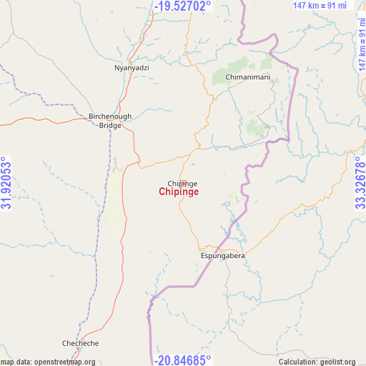
Chipinge GPS coordinates[2]
20° 11' 17.988" South, 32° 37' 25.14" East
| Map corner | latitude | longitude |
|---|---|---|
| Upper-left | -19.52702°, | 31.92053° |
| Center: | -20.18833°, | 32.62365° |
| Lower-right: | -20.84685°, | 33.32678° |
| Map W x H: | 146.8×146.8 km | = 91.2×91.2mi |
| max Lat: | -16.03333° ⇑89.2% North |
| Chipinge: | -20.18833° |
| min Lat: | ⇓10.8% South -22.21667° |
| min Long | Chipinge | max Long |
| 25.83066° | 32.62365° | 32.86667° |
| W 93.8%⇐ | ⇒6.2% E |
Elevation
Elevation of Chipinge is 1109 m = 3638 ft, and this is 88.7 m = 291 ft below average elevation for this country.
| Max E: |
1706 m = 5597 ft | 69.2% |
| Avg. | 1197.7 m = 3929 ft | |
| Chipinge | 1109 m = 3638 ft | |
Min E: |
402 m = 1319 ft | 30.8% |
See also: Zimbabwe elevation on elevation.city.
Geographical zone
Chipinge is located in South Torrid zone (between Equator and Tropic of Capricorn). Distance of this Southern Tropic circle is 361.2 km =224.4 mi to South.| Distance of | km | miles | from Chipinge |
|---|---|---|---|
| Equator | 2244.7 | 1394.8 | to North |
| Tropic Capricorn | 361.2 | 224.4 | to South |
| Antarctic Circle | 5156.4 | 3204 | to South |
| South Pole | 7762.3 | 4823.3 | to South |


Nearby cities:
15 places around Chipinge: (largest is in red/bold)
• Chimanimani
50.1 km =31.1 mi,  30°
30°
• Chiredzi
138.2 km =85.9 mi,  226°
226°
• Chivhu
223 km =138.6 mi,  305°
305°
• Dorowa Mining Lease
154.7 km =96.1 mi,  323°
323°
• Headlands
220.8 km =137.2 mi,  344°
344°
• Macheke
241.9 km =150.3 mi, 340°
• Mashava
224.2 km =139.3 mi,  274°
274°
• Masvingo
188 km =116.8 mi, 274°
• Mutare
135.5 km =84.2 mi,  2°
2°
• Mvuma
241.5 km =150.1 mi,  294°
294°
• Nyanga
219.6 km =136.5 mi, 3°
• Nyazura
171.6 km =106.6 mi, 343°
• Odzi
138.3 km =85.9 mi,  350°
350°
• Penhalonga
144.4 km =89.7 mi, 3°
• Rusape
191.8 km =119.2 mi, 344°
Sources, notices
• [Note1] Compared only with cities in Zimbabwe existing in our database
• [Src1] Map data: © OpenStreetMap contributors (CC-BY-SA)
• [Src2] Other city data from geonames.org with taken over terms of usage.
• [Src3] Geographical zone / Annual Mean Temperature by Robert A. Rohde @ Wikipedia
