Chiredzi geodata
Chiredzi (Masvingo) is a populated place; located in Zimbabwe in Africa/Harare (GMT+2) time zone. With population of 28,205 people, there are 20 cities with bigger population in this country. Compared to other cities in Zimbabwe, 98.5% of cities are located further ↑North; 80% of cities are located further ←West and 98.5% of cities have higher elevation than Chiredzi. Note1


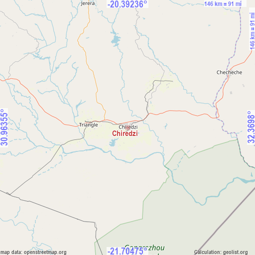
Chiredzi GPS coordinates[2]
21° 3' 0" South, 31° 40' 0.012" East
| Map corner | latitude | longitude |
|---|---|---|
| Upper-left | -20.39236°, | 30.96355° |
| Center: | -21.05°, | 31.66667° |
| Lower-right: | -21.70475°, | 32.3698° |
| Map W x H: | 145.9×145.9 km | = 90.7×90.7mi |
| max Lat: | -16.03333° ⇑98.5% North |
| Chiredzi: | -21.05° |
| min Lat: | ⇓1.5% South -22.21667° |
| min Long | Chiredzi | max Long |
| 25.83066° | 31.66667° | 32.86667° |
| W 80%⇐ | ⇒20% E |
Elevation
Elevation of Chiredzi is 436 m = 1430 ft, and this is 761.7 m = 2499 ft below average elevation for this country.
| Max E: |
1706 m = 5597 ft | 98.5% |
| Avg. | 1197.7 m = 3929 ft | |
| Chiredzi | 436 m = 1430 ft | |
Min E: |
402 m = 1319 ft | 1.5% |
See also: Zimbabwe elevation on elevation.city.
Geographical zone
Chiredzi is located in South Torrid zone (between Equator and Tropic of Capricorn). Distance of this Southern Tropic circle is 265.4 km =164.9 mi to South.| Distance of | km | miles | from Chiredzi |
|---|---|---|---|
| Equator | 2340.5 | 1454.3 | to North |
| Tropic Capricorn | 265.4 | 164.9 | to South |
| Antarctic Circle | 5060.6 | 3144.5 | to South |
| South Pole | 7666.5 | 4763.7 | to South |


Nearby cities:
15 places around Chiredzi: (largest is in red/bold)
• Beitbridge
215.6 km =134 mi,  233°
233°
• Chimanimani
187 km =116.2 mi,  41°
41°
• Chipinge
138.2 km =85.9 mi,  46°
46°
• Chivhu
239.7 km =148.9 mi,  340°
340°
• Dorowa Mining Lease
220.7 km =137.1 mi,  2°
2°
• Filabusi
254.1 km =157.9 mi,  283°
283°
• Gweru
262.5 km =163.1 mi,  312°
312°
• Lalapanzi
246.2 km =153 mi,  320°
320°
• Mashava
167 km =103.8 mi, 312°
• Masvingo
140.2 km =87.1 mi, 321°
• Mutare
253.9 km =157.8 mi,  24°
24°
• Mvuma
230 km =142.9 mi,  328°
328°
• Odzi
244.7 km =152 mi, 18°
• Shurugwi
231.3 km =143.7 mi, 311°
• Zvishavane
184.9 km =114.9 mi,  295°
295°
Sources, notices
• [Note1] Compared only with cities in Zimbabwe existing in our database
• [Src1] Map data: © OpenStreetMap contributors (CC-BY-SA)
• [Src2] Other city data from geonames.org with taken over terms of usage.
• [Src3] Geographical zone / Annual Mean Temperature by Robert A. Rohde @ Wikipedia
