Beitbridge geodata
Beitbridge (Matabeleland South) is a populated place; located in Zimbabwe in Africa/Harare (GMT+2) time zone. With population of 26,459 people, there are 21 cities with bigger population in this country. Compared to other cities in Zimbabwe, 100% of cities are located further ↑North; 64.6% of cities are located further →East and 96.9% of cities have higher elevation than Beitbridge. Note1


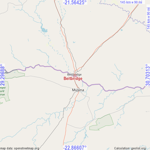
Beitbridge GPS coordinates[2]
22° 13' 0.012" South, 30° 0' 0" East
| Map corner | latitude | longitude |
|---|---|---|
| Upper-left | -21.56425°, | 29.29688° |
| Center: | -22.21667°, | 30° |
| Lower-right: | -22.86607°, | 30.70313° |
| Map W x H: | 144.7×144.8 km | = 89.9×90mi |
| max Lat: | -16.03333° ⇑100% North |
| Beitbridge: | -22.21667° |
| min Lat: | ⇓0% South -22.21667° |
| min Long | Beitbridge | max Long |
| 25.83066° | 30° | 32.86667° |
| W 35.4%⇐ | ⇒64.6% E |
Elevation
Elevation of Beitbridge is 461 m = 1512 ft, and this is 736.7 m = 2417 ft below average elevation for this country.
| Max E: |
1706 m = 5597 ft | 96.9% |
| Avg. | 1197.7 m = 3929 ft | |
| Beitbridge | 461 m = 1512 ft | |
Min E: |
402 m = 1319 ft | 3.1% |
See also: Zimbabwe elevation on elevation.city.
Geographical zone
Beitbridge is located in South Torrid zone (between Equator and Tropic of Capricorn). Distance of this Southern Tropic circle is 135.7 km =84.3 mi to South.| Distance of | km | miles | from Beitbridge |
|---|---|---|---|
| Equator | 2470.3 | 1535 | to North |
| Tropic Capricorn | 135.7 | 84.3 | to South |
| Antarctic Circle | 4930.9 | 3063.9 | to South |
| South Pole | 7536.8 | 4683.1 | to South |


Nearby cities:
15 places around Beitbridge: (largest is in red/bold)
• Bulawayo
272.7 km =169.4 mi,  327°
327°
• Chiredzi
215.6 km =134 mi,  53°
53°
• Esigodini
241.6 km =150.1 mi, 332°
• Filabusi
201.3 km =125.1 mi,  338°
338°
• Gwanda
175.5 km =109.1 mi,  324°
324°
• Gweru
308.2 km =191.5 mi,  356°
356°
• Insiza
283 km =175.8 mi, 342°
• Inyati
306.9 km =190.7 mi, 337°
• Lalapanzi
321.2 km =199.6 mi,  3°
3°
• Mashava
247.5 km =153.8 mi,  11°
11°
• Masvingo
254.3 km =158 mi,  19°
19°
• Plumtree
297.1 km =184.6 mi,  310°
310°
• Shangani
278.4 km =173 mi,  346°
346°
• Shurugwi
283.1 km =175.9 mi, 0°
• Zvishavane
210.3 km =130.7 mi, 1°
Sources, notices
• [Note1] Compared only with cities in Zimbabwe existing in our database
• [Src1] Map data: © OpenStreetMap contributors (CC-BY-SA)
• [Src2] Other city data from geonames.org with taken over terms of usage.
• [Src3] Geographical zone / Annual Mean Temperature by Robert A. Rohde @ Wikipedia
