Karoi geodata
Karoi (Mashonaland West) is a populated place; located in Zimbabwe in Africa/Harare (GMT+2) time zone. With population of 25,030 people, there are 23 cities with bigger population in this country. Compared to other cities in Zimbabwe, 93.8% of cities are located further ↓South; 73.8% of cities are located further →East and 56.9% of cities have lower elevation than Karoi. Note1


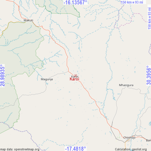
Karoi GPS coordinates[2]
16° 48' 35.748" South, 29° 41' 32.892" East
| Map corner | latitude | longitude |
|---|---|---|
| Upper-left | -16.13567°, | 28.98935° |
| Center: | -16.80993°, | 29.69247° |
| Lower-right: | -17.4818°, | 30.3956° |
| Map W x H: | 149.7×149.7 km | = 93×93mi |
| max Lat: | -16.03333° ⇑6.2% North |
| Karoi: | -16.80993° |
| min Lat: | ⇓93.8% South -22.21667° |
| min Long | Karoi | max Long |
| 25.83066° | 29.69247° | 32.86667° |
| W 26.2%⇐ | ⇒73.8% E |
Elevation
Elevation of Karoi is 1259 m = 4131 ft, and this is 61.3 m = 201 ft above average elevation for this country.
| Max E: |
1706 m = 5597 ft | 43.1% |
| Karoi | 1259 m 4131 ft | |
| Avg. | 1197.7 m = 3929 ft | |
Min E: |
402 m = 1319 ft | 56.9% |
See also: Zimbabwe elevation on elevation.city.
Geographical zone
Karoi is located in South Torrid zone (between Equator and Tropic of Capricorn). Distance of this Southern Tropic circle is 736.8 km =457.8 mi to South.| Distance of | km | miles | from Karoi |
|---|---|---|---|
| Equator | 1869.1 | 1161.4 | to North |
| Tropic Capricorn | 736.8 | 457.8 | to South |
| Antarctic Circle | 5532.1 | 3437.5 | to South |
| South Pole | 8138 | 5056.7 | to South |


Nearby cities:
15 places around Karoi: (largest is in red/bold)
• Banket
98.6 km =61.3 mi,  130°
130°
• Centenary
151.7 km =94.3 mi,  86°
86°
• Chakari
140.9 km =87.6 mi,  171°
171°
• Chegutu
154.3 km =95.9 mi,  162°
162°
• Chinhoyi
82.1 km =51 mi,  138°
138°
• Chirundu
124.6 km =77.4 mi,  313°
313°
• Concession
148.1 km =92 mi,  115°
115°
• Glendale
158.2 km =98.3 mi,  112°
112°
• Kadoma
171 km =106.3 mi, 172°
• Kariba
100.5 km =62.4 mi,  288°
288°
• Mazowe
156.5 km =97.2 mi, 119°
• Mhangura
51.5 km =32 mi,  100°
100°
• Mvurwi
125.6 km =78 mi, 101°
• Norton
160.2 km =99.5 mi, 138°
• Raffingora
82.6 km =51.3 mi, 107°
Sources, notices
• [Note1] Compared only with cities in Zimbabwe existing in our database
• [Src1] Map data: © OpenStreetMap contributors (CC-BY-SA)
• [Src2] Other city data from geonames.org with taken over terms of usage.
• [Src3] Geographical zone / Annual Mean Temperature by Robert A. Rohde @ Wikipedia
