Zīārat-e Shāh Maqşūd geodata
Zīārat-e Shāh Maqşūd (Kandahar) is a seat of a second-order administrative division; located in Afghanistan in Asia/Kabul (GMT+4.5) time zone. In our database, there are 93 cities with bigger population. Compared to other cities in Afghanistan, 92.9% of cities are located further ↑North; 76.8% of cities are located further →East and 58.2% of cities have lower elevation than Zīārat-e Shāh Maqşūd. Note1


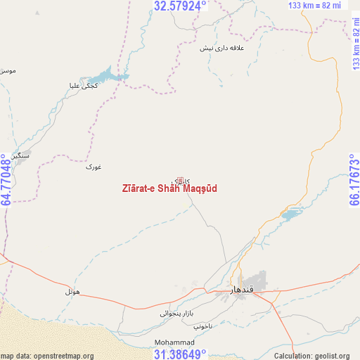
Zīārat-e Shāh Maqşūd GPS coordinates[2]
31° 59' 5.28" North, 65° 28' 24.96" East
| Map corner | latitude | longitude |
|---|---|---|
| Upper-left | 32.57924°, | 64.77048° |
| Center: | 31.9848°, | 65.4736° |
| Lower-right: | 31.38649°, | 66.17673° |
| Map W x H: | 132.6×132.6 km | = 82.4×82.4mi |
| max Lat: | 38.4435° ⇑92.9% North |
| Zīārat-e Shāh Maqşūd: | 31.9848° |
| min Lat: | ⇓7.1% South 30.15° |
| min Long | Zīārat-e Shā | max Long |
| 61.06667° | 65.4736° | 72.318° |
| W 23.2%⇐ | ⇒76.8% E |
Elevation
Elevation of Zīārat-e Shāh Maqşūd is 1577 m = 5174 ft, and this is 158.6 m = 520 ft above average elevation for this country.
| Max E: |
3068 m = 10066 ft | 41.8% |
| Zīārat-e Shāh Maqşūd | 1577 m 5174 ft | |
| Avg. | 1418.4 m = 4654 ft | |
Min E: |
254 m = 833 ft | 58.2% |
See also: Afghanistan elevation on elevation.city.
Geographical zone
Zīārat-e Shāh Maqşūd is located in North temperate zone (between Tropic of Cancer and the Arctic Circle). Distance of this Northern Tropic circle is 950.5 km =590.6 mi to South.| Distance of | km | miles | from Zīārat-e Shāh Maqşūd |
|---|---|---|---|
| North Pole | 6450.7 | 4008.3 | to North |
| Arctic Circle | 3844.8 | 2389 | to North |
| Tropic Cancer | 950.5 | 590.6 | to South |
| Equator | 3556.4 | 2209.8 | to South |


Nearby cities:
15 places around Zīārat-e Shāh Maqşūd: (largest is in red/bold)
• Arghestān
107 km =66.5 mi,  116°
116°
• Babasakhib
40.1 km =24.9 mi,  153°
153°
• Chinār
34.7 km =21.6 mi,  275°
275°
• Dê Nārkhēl Kêlay
52 km =32.3 mi,  16°
16°
• Gereshk
87.2 km =54.2 mi,  257°
257°
• Kandahār
47 km =29.2 mi, 151°
• Kishk-e Nakhūd
56.2 km =34.9 mi,  224°
224°
• Mīzān ‘Alāqahdārī
100.2 km =62.3 mi,  77°
77°
• Mūsá Qal‘ah
85.6 km =53.2 mi,  306°
306°
• Now Zād
105.3 km =65.4 mi,  296°
296°
• Pāshmūl
47.7 km =29.6 mi,  184°
184°
• Sangīn
60.9 km =37.8 mi, 279°
• Shahr-e Şafā
82.8 km =51.4 mi,  104°
104°
• Tarinkot
81.2 km =50.5 mi,  27°
27°
• Zamtō Kêlay
79 km =49.1 mi,  56°
56°
Sources, notices
• [Note1] Compared only with cities in Afghanistan existing in our database
• [Src1] Map data: © OpenStreetMap contributors (CC-BY-SA)
• [Src2] Other city data from geonames.org with taken over terms of usage.
• [Src3] Geographical zone / Annual Mean Temperature by Robert A. Rohde @ Wikipedia
