Kandahār geodata
Kandahār (Kandahar) is a seat of a first-order administrative division; located in Afghanistan in Asia/Kabul (GMT+4.5) time zone. With population of 391,190 people, there is 1 city with bigger population in this country. Compared to other cities in Afghanistan, 95.8% of cities are located further ↑North; 74.9% of cities are located further →East and 65.6% of cities have higher elevation than Kandahār. Note1


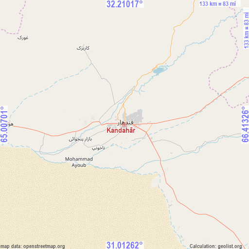
Kandahār GPS coordinates[2]
31° 36' 47.952" North, 65° 42' 36.468" East
| Map corner | latitude | longitude |
|---|---|---|
| Upper-left | 32.21017°, | 65.00701° |
| Center: | 31.61332°, | 65.71013° |
| Lower-right: | 31.01262°, | 66.41326° |
| Map W x H: | 133.2×133.2 km | = 82.8×82.8mi |
| max Lat: | 38.4435° ⇑95.8% North |
| Kandahār: | 31.61332° |
| min Lat: | ⇓4.2% South 30.15° |
| min Long | Kandahār | max Long |
| 61.06667° | 65.71013° | 72.318° |
| W 25.1%⇐ | ⇒74.9% E |
Elevation
Elevation of Kandahār is 1007 m = 3304 ft, and this is 411.4 m = 1350 ft below average elevation for this country.
| Max E: |
3068 m = 10066 ft | 65.6% |
| Avg. | 1418.4 m = 4654 ft | |
| Kandahār | 1007 m = 3304 ft | |
Min E: |
254 m = 833 ft | 34.4% |
See also: Kandahār elevation on elevation.city.
Geographical zone
Kandahār is located in North temperate zone (between Tropic of Cancer and the Arctic Circle). Distance of this Northern Tropic circle is 909.2 km =565 mi to South.| Distance of | km | miles | from Kandahār |
|---|---|---|---|
| North Pole | 6492 | 4033.9 | to North |
| Arctic Circle | 3886.1 | 2414.7 | to North |
| Tropic Cancer | 909.2 | 565 | to South |
| Equator | 3515.1 | 2184.2 | to South |


Nearby cities:
15 places around Kandahār: (largest is in red/bold)
• Arghestān
74 km =46 mi,  94°
94°
• Babasakhib
7.1 km =4.4 mi,  318°
318°
• Chinār
72.4 km =45 mi,  308°
308°
• Dê Nārkhēl Kêlay
91.3 km =56.7 mi,  355°
355°
• Gereshk
110.3 km =68.5 mi,  282°
282°
• Khūgyāṉī
82.7 km =51.4 mi, 93°
• Kishk-e Nakhūd
62 km =38.5 mi,  271°
271°
• Mīzān ‘Alāqahdārī
98.3 km =61.1 mi,  50°
50°
• Pāshmūl
26.9 km =16.7 mi,  256°
256°
• Sangīn
97.1 km =60.3 mi,  301°
301°
• Shahr-e Şafā
61.8 km =38.4 mi,  69°
69°
• Spīn Bōldak
94.1 km =58.5 mi,  135°
135°
• Tarinkot
114.1 km =70.9 mi,  7°
7°
• Zamtō Kêlay
95.2 km =59.2 mi,  27°
27°
• Zīārat-e Shāh Maqşūd
47 km =29.2 mi,  331°
331°
In other languages:
- In Spanish: Kandahar
- In France: Kandahar
- In German: Kandahar
- In Italian: Kandahar
- In Russian: Кандагар
- In Chinese: 坎大哈
Sources, notices
• [Note1] Compared only with cities in Afghanistan existing in our database
• [Src1] Map data: © OpenStreetMap contributors (CC-BY-SA)
• [Src2] Other city data from geonames.org with taken over terms of usage.
• [Src3] Geographical zone / Annual Mean Temperature by Robert A. Rohde @ Wikipedia
