Babasakhib geodata
Babasakhib (Kandahar) is a seat of a second-order administrative division; located in Afghanistan in Asia/Kabul (GMT+4.5) time zone. In our database, there are 93 cities with bigger population. Compared to other cities in Afghanistan, 94.9% of cities are located further ↑North; 75.6% of cities are located further →East and 65% of cities have higher elevation than Babasakhib. Note1


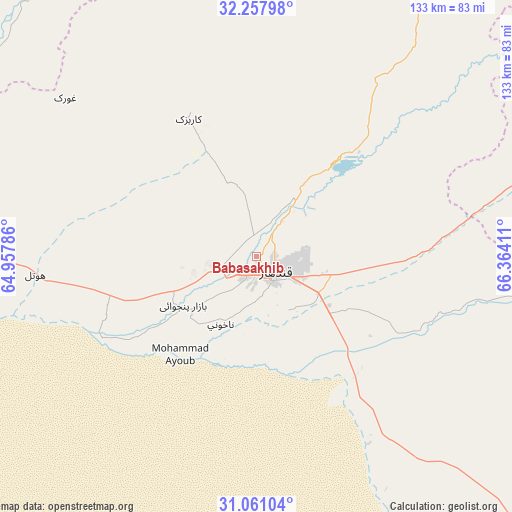
Babasakhib GPS coordinates[2]
31° 39' 41.184" North, 65° 39' 39.528" East
| Map corner | latitude | longitude |
|---|---|---|
| Upper-left | 32.25798°, | 64.95786° |
| Center: | 31.66144°, | 65.66098° |
| Lower-right: | 31.06104°, | 66.36411° |
| Map W x H: | 133.1×133.1 km | = 82.7×82.7mi |
| max Lat: | 38.4435° ⇑94.9% North |
| Babasakhib: | 31.66144° |
| min Lat: | ⇓5.1% South 30.15° |
| min Long | Babasakhib | max Long |
| 61.06667° | 65.66098° | 72.318° |
| W 24.4%⇐ | ⇒75.6% E |
Elevation
Elevation of Babasakhib is 1014 m = 3327 ft, and this is 404.4 m = 1327 ft below average elevation for this country.
| Max E: |
3068 m = 10066 ft | 65% |
| Avg. | 1418.4 m = 4654 ft | |
| Babasakhib | 1014 m = 3327 ft | |
Min E: |
254 m = 833 ft | 35% |
See also: Afghanistan elevation on elevation.city.
Geographical zone
Babasakhib is located in North temperate zone (between Tropic of Cancer and the Arctic Circle). Distance of this Northern Tropic circle is 914.5 km =568.2 mi to South.| Distance of | km | miles | from Babasakhib |
|---|---|---|---|
| North Pole | 6486.6 | 4030.6 | to North |
| Arctic Circle | 3880.8 | 2411.4 | to North |
| Tropic Cancer | 914.5 | 568.2 | to South |
| Equator | 3520.4 | 2187.5 | to South |


Nearby cities:
15 places around Babasakhib: (largest is in red/bold)
• Arghestān
79.2 km =49.2 mi,  98°
98°
• Chinār
65.5 km =40.7 mi,  306°
306°
• Dê Nārkhēl Kêlay
85.7 km =53.3 mi,  358°
358°
• Gereshk
104.7 km =65.1 mi,  279°
279°
• Kandahār
7.1 km =4.4 mi,  138°
138°
• Khūgyāṉī
87.8 km =54.6 mi, 97°
• Kishk-e Nakhūd
57.5 km =35.7 mi,  265°
265°
• Mīzān ‘Alāqahdārī
98.7 km =61.3 mi,  54°
54°
• Pāshmūl
24.4 km =15.2 mi,  241°
241°
• Sangīn
90.3 km =56.1 mi,  300°
300°
• Shahr-e Şafā
64.6 km =40.1 mi,  75°
75°
• Spīn Bōldak
101.2 km =62.9 mi, 136°
• Tarinkot
109.6 km =68.1 mi,  10°
10°
• Zamtō Kêlay
92.8 km =57.7 mi,  31°
31°
• Zīārat-e Shāh Maqşūd
40.1 km =24.9 mi,  333°
333°
Sources, notices
• [Note1] Compared only with cities in Afghanistan existing in our database
• [Src1] Map data: © OpenStreetMap contributors (CC-BY-SA)
• [Src2] Other city data from geonames.org with taken over terms of usage.
• [Src3] Geographical zone / Annual Mean Temperature by Robert A. Rohde @ Wikipedia
