Shahr-e Şafā geodata
Shahr-e Şafā (Zabul) is a seat of a second-order administrative division; located in Afghanistan in Asia/Kabul (GMT+4.5) time zone. In our database, there are 93 cities with bigger population. Compared to other cities in Afghanistan, 93.9% of cities are located further ↑North; 67.5% of cities are located further →East and 55% of cities have higher elevation than Shahr-e Şafā. Note1


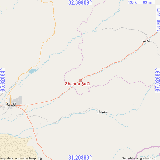
Shahr-e Şafā GPS coordinates[2]
31° 48' 12.492" North, 66° 19' 25.536" East
| Map corner | latitude | longitude |
|---|---|---|
| Upper-left | 32.39909°, | 65.62064° |
| Center: | 31.80347°, | 66.32376° |
| Lower-right: | 31.20399°, | 67.02689° |
| Map W x H: | 132.9×132.9 km | = 82.6×82.6mi |
| max Lat: | 38.4435° ⇑93.9% North |
| Shahr-e Şafā: | 31.80347° |
| min Lat: | ⇓6.1% South 30.15° |
| min Long | Shahr-e Şafā | max Long |
| 61.06667° | 66.32376° | 72.318° |
| W 32.5%⇐ | ⇒67.5% E |
Elevation
Elevation of Shahr-e Şafā is 1257 m = 4124 ft, and this is 161.4 m = 530 ft below average elevation for this country.
| Max E: |
3068 m = 10066 ft | 55% |
| Avg. | 1418.4 m = 4654 ft | |
| Shahr-e Şafā | 1257 m = 4124 ft | |
Min E: |
254 m = 833 ft | 45% |
See also: Afghanistan elevation on elevation.city.
Geographical zone
Shahr-e Şafā is located in North temperate zone (between Tropic of Cancer and the Arctic Circle). Distance of this Northern Tropic circle is 930.3 km =578.1 mi to South.| Distance of | km | miles | from Shahr-e Şafā |
|---|---|---|---|
| North Pole | 6470.8 | 4020.8 | to North |
| Arctic Circle | 3865 | 2401.6 | to North |
| Tropic Cancer | 930.3 | 578.1 | to South |
| Equator | 3536.2 | 2197.3 | to South |


Nearby cities:
15 places around Shahr-e Şafā: (largest is in red/bold)
• Arghestān
31.3 km =19.4 mi,  149°
149°
• Babasakhib
64.6 km =40.1 mi,  255°
255°
• Dê Nārkhēl Kêlay
95.4 km =59.3 mi,  317°
317°
• Kandahār
61.8 km =38.4 mi,  249°
249°
• Khūgyāṉī
36.2 km =22.5 mi,  137°
137°
• Mīzān ‘Alāqahdārī
45.1 km =28 mi,  23°
23°
• Nāyak
95.4 km =59.3 mi,  26°
26°
• Pāshmūl
88.5 km =55 mi, 251°
• Qalāt
64.6 km =40.1 mi,  58°
58°
• Spīn Bōldak
89 km =55.3 mi,  175°
175°
• Tarinkot
101 km =62.8 mi,  335°
335°
• Zamtō Kêlay
64.8 km =40.3 mi,  347°
347°
• Zīārat-e Shāh Maqşūd
82.8 km =51.4 mi,  284°
284°
• Ḩukūmat-e Shīnkaī
97.6 km =60.6 mi,  78°
78°
• ‘Alāqahdārī Aṯghar
98 km =60.9 mi,  94°
94°
Sources, notices
• [Note1] Compared only with cities in Afghanistan existing in our database
• [Src1] Map data: © OpenStreetMap contributors (CC-BY-SA)
• [Src2] Other city data from geonames.org with taken over terms of usage.
• [Src3] Geographical zone / Annual Mean Temperature by Robert A. Rohde @ Wikipedia
