Arghestān geodata
Arghestān (Kandahar) is a populated place; located in Afghanistan in Asia/Kabul (GMT+4.5) time zone. With population of 894 people, there are 92 cities with bigger population in this country. Compared to other cities in Afghanistan, 96.8% of cities are located further ↑North; 65.9% of cities are located further →East and 54% of cities have higher elevation than Arghestān. Note1


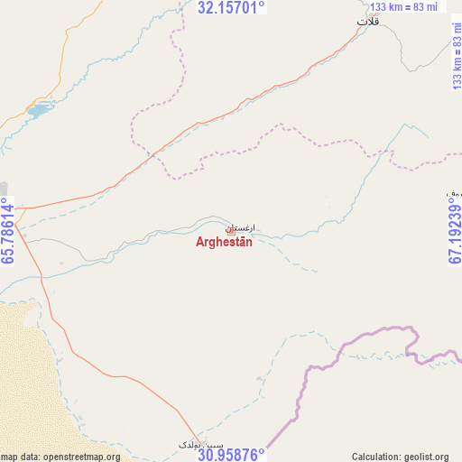
Arghestān GPS coordinates[2]
31° 33' 35.316" North, 66° 29' 21.336" East
| Map corner | latitude | longitude |
|---|---|---|
| Upper-left | 32.15701°, | 65.78614° |
| Center: | 31.55981°, | 66.48926° |
| Lower-right: | 30.95876°, | 67.19239° |
| Map W x H: | 133.2×133.2 km | = 82.8×82.8mi |
| max Lat: | 38.4435° ⇑96.8% North |
| Arghestān: | 31.55981° |
| min Lat: | ⇓3.2% South 30.15° |
| min Long | Arghestān | max Long |
| 61.06667° | 66.48926° | 72.318° |
| W 34.1%⇐ | ⇒65.9% E |
Elevation
Elevation of Arghestān is 1263 m = 4144 ft, and this is 155.4 m = 510 ft below average elevation for this country.
| Max E: |
3068 m = 10066 ft | 54% |
| Avg. | 1418.4 m = 4654 ft | |
| Arghestān | 1263 m = 4144 ft | |
Min E: |
254 m = 833 ft | 46% |
See also: Afghanistan elevation on elevation.city.
Geographical zone
Arghestān is located in North temperate zone (between Tropic of Cancer and the Arctic Circle). Distance of this Northern Tropic circle is 903.2 km =561.2 mi to South.| Distance of | km | miles | from Arghestān |
|---|---|---|---|
| North Pole | 6497.9 | 4037.6 | to North |
| Arctic Circle | 3892.1 | 2418.4 | to North |
| Tropic Cancer | 903.2 | 561.2 | to South |
| Equator | 3509.1 | 2180.5 | to South |


Nearby cities:
15 places around Arghestān: (largest is in red/bold)
• Babasakhib
79.2 km =49.2 mi,  278°
278°
• Dê Nārkhēl Kêlay
126.1 km =78.4 mi,  320°
320°
• Kandahār
74 km =46 mi,  274°
274°
• Khūgyāṉī
8.7 km =5.4 mi,  87°
87°
• Mīzān ‘Alāqahdārī
68.6 km =42.6 mi,  1°
1°
• Nāyak
115.7 km =71.9 mi,  13°
13°
• Pāshmūl
100 km =62.1 mi, 269°
• Qalāt
72.5 km =45 mi,  33°
33°
• Shahr-e Şafā
31.3 km =19.4 mi,  329°
329°
• Spīn Bōldak
62.2 km =38.6 mi,  187°
187°
• Sāyagaz
123 km =76.4 mi,  24°
24°
• Zamtō Kêlay
95.1 km =59.1 mi,  341°
341°
• Zīārat-e Shāh Maqşūd
107 km =66.5 mi,  296°
296°
• Ḩukūmat-e Shīnkaī
92.8 km =57.7 mi,  59°
59°
• ‘Alāqahdārī Aṯghar
84.5 km =52.5 mi,  76°
76°
Sources, notices
• [Note1] Compared only with cities in Afghanistan existing in our database
• [Src1] Map data: © OpenStreetMap contributors (CC-BY-SA)
• [Src2] Other city data from geonames.org with taken over terms of usage.
• [Src3] Geographical zone / Annual Mean Temperature by Robert A. Rohde @ Wikipedia
