Gereshk geodata
Gereshk (Helmand) is a seat of a second-order administrative division; located in Afghanistan in Asia/Kabul (GMT+4.5) time zone. With population of 43,588 people, there are 27 cities with bigger population in this country. Compared to other cities in Afghanistan, 93.6% of cities are located further ↑North; 83.6% of cities are located further →East and 75.2% of cities have higher elevation than Gereshk. Note1


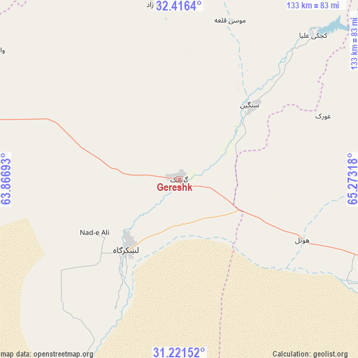
Gereshk GPS coordinates[2]
31° 49' 15.204" North, 64° 34' 12.18" East
| Map corner | latitude | longitude |
|---|---|---|
| Upper-left | 32.4164°, | 63.86693° |
| Center: | 31.82089°, | 64.57005° |
| Lower-right: | 31.22152°, | 65.27318° |
| Map W x H: | 132.9×132.9 km | = 82.6×82.6mi |
| max Lat: | 38.4435° ⇑93.6% North |
| Gereshk: | 31.82089° |
| min Lat: | ⇓6.4% South 30.15° |
| min Long | Gereshk | max Long |
| 61.06667° | 64.57005° | 72.318° |
| W 16.4%⇐ | ⇒83.6% E |
Elevation
Elevation of Gereshk is 830 m = 2723 ft, and this is 588.4 m = 1930 ft below average elevation for this country.
| Max E: |
3068 m = 10066 ft | 75.2% |
| Avg. | 1418.4 m = 4654 ft | |
| Gereshk | 830 m = 2723 ft | |
Min E: |
254 m = 833 ft | 24.8% |
See also: Gereshk elevation on elevation.city.
Geographical zone
Gereshk is located in North temperate zone (between Tropic of Cancer and the Arctic Circle). Distance of this Northern Tropic circle is 932.2 km =579.2 mi to South.| Distance of | km | miles | from Gereshk |
|---|---|---|---|
| North Pole | 6468.9 | 4019.6 | to North |
| Arctic Circle | 3863 | 2400.4 | to North |
| Tropic Cancer | 932.2 | 579.2 | to South |
| Equator | 3538.2 | 2198.5 | to South |


Nearby cities:
15 places around Gereshk: (largest is in red/bold)
• Babasakhib
104.7 km =65.1 mi,  99°
99°
• Chinār
55.1 km =34.2 mi,  66°
66°
• Dê Nārkhēl Kêlay
121.1 km =75.2 mi,  55°
55°
• Kandahār
110.3 km =68.5 mi, 102°
• Kishk-e Nakhūd
50.8 km =31.6 mi,  115°
115°
• Lashkar Gāh
31.5 km =19.6 mi,  216°
216°
• Markaz-e Ḩukūmat-e Darwēshān
84.5 km =52.5 mi,  205°
205°
• Mūsá Qal‘ah
71.4 km =44.4 mi,  13°
13°
• Now Zād
65.4 km =40.6 mi,  351°
351°
• Pāshmūl
86.9 km =54 mi,  109°
109°
• Qal‘ah-ye Kuhnah
122.6 km =76.2 mi,  316°
316°
• Sangīn
37.6 km =23.4 mi,  41°
41°
• Wāshēr
82.6 km =51.3 mi,  305°
305°
• Zīārat-e Shāh Maqşūd
87.2 km =54.2 mi,  77°
77°
• Ḩukūmat-e Nād ‘Alī
37 km =23 mi,  237°
237°
Sources, notices
• [Note1] Compared only with cities in Afghanistan existing in our database
• [Src1] Map data: © OpenStreetMap contributors (CC-BY-SA)
• [Src2] Other city data from geonames.org with taken over terms of usage.
• [Src3] Geographical zone / Annual Mean Temperature by Robert A. Rohde @ Wikipedia
