Kishk-e Nakhūd geodata
Kishk-e Nakhūd (Kandahar) is a seat of a second-order administrative division; located in Afghanistan in Asia/Kabul (GMT+4.5) time zone. In our database, there are 93 cities with bigger population. Compared to other cities in Afghanistan, 95.5% of cities are located further ↑North; 80.4% of cities are located further →East and 69.5% of cities have higher elevation than Kishk-e Nakhūd. Note1


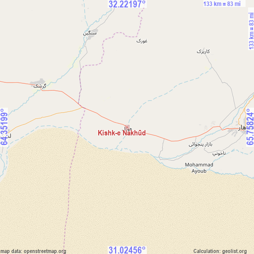
Kishk-e Nakhūd GPS coordinates[2]
31° 37' 30.684" North, 65° 3' 18.396" East
| Map corner | latitude | longitude |
|---|---|---|
| Upper-left | 32.22197°, | 64.35199° |
| Center: | 31.62519°, | 65.05511° |
| Lower-right: | 31.02456°, | 65.75824° |
| Map W x H: | 133.1×133.1 km | = 82.7×82.7mi |
| max Lat: | 38.4435° ⇑95.5% North |
| Kishk-e Nakhūd: | 31.62519° |
| min Lat: | ⇓4.5% South 30.15° |
| min Long | Kishk-e Nakhūd | max Long |
| 61.06667° | 65.05511° | 72.318° |
| W 19.6%⇐ | ⇒80.4% E |
Elevation
Elevation of Kishk-e Nakhūd is 944 m = 3097 ft, and this is 474.4 m = 1556 ft below average elevation for this country.
| Max E: |
3068 m = 10066 ft | 69.5% |
| Avg. | 1418.4 m = 4654 ft | |
| Kishk-e Nakhūd | 944 m = 3097 ft | |
Min E: |
254 m = 833 ft | 30.5% |
See also: Afghanistan elevation on elevation.city.
Geographical zone
Kishk-e Nakhūd is located in North temperate zone (between Tropic of Cancer and the Arctic Circle). Distance of this Northern Tropic circle is 910.5 km =565.8 mi to South.| Distance of | km | miles | from Kishk-e Nakhūd |
|---|---|---|---|
| North Pole | 6490.7 | 4033.1 | to North |
| Arctic Circle | 3884.8 | 2413.9 | to North |
| Tropic Cancer | 910.5 | 565.8 | to South |
| Equator | 3516.4 | 2185 | to South |


Nearby cities:
15 places around Kishk-e Nakhūd: (largest is in red/bold)
• Babasakhib
57.5 km =35.7 mi,  85°
85°
• Chinār
43.7 km =27.2 mi,  6°
6°
• Dê Nārkhēl Kêlay
105 km =65.2 mi,  31°
31°
• Gereshk
50.8 km =31.6 mi,  295°
295°
• Kandahār
62 km =38.5 mi, 91°
• Lashkar Gāh
64.8 km =40.3 mi,  266°
266°
• Markaz-e Ḩukūmat-e Darwēshān
98.5 km =61.2 mi,  236°
236°
• Mūsá Qal‘ah
95.8 km =59.5 mi,  342°
342°
• Now Zād
102.6 km =63.8 mi,  327°
327°
• Pāshmūl
36.7 km =22.8 mi,  101°
101°
• Sangīn
53.9 km =33.5 mi, 337°
• Shahr-e Şafā
121.6 km =75.6 mi,  80°
80°
• Wāshēr
132.9 km =82.6 mi, 301°
• Zīārat-e Shāh Maqşūd
56.2 km =34.9 mi,  44°
44°
• Ḩukūmat-e Nād ‘Alī
77.2 km =48 mi, 271°
Sources, notices
• [Note1] Compared only with cities in Afghanistan existing in our database
• [Src1] Map data: © OpenStreetMap contributors (CC-BY-SA)
• [Src2] Other city data from geonames.org with taken over terms of usage.
• [Src3] Geographical zone / Annual Mean Temperature by Robert A. Rohde @ Wikipedia
