Tarinkot geodata
Tarinkot (Oruzgan) is a seat of a first-order administrative division; located in Afghanistan in Asia/Kabul (GMT+4.5) time zone. With population of 10,000 people, there are 69 cities with bigger population in this country. Compared to other cities in Afghanistan, 86.8% of cities are located further ↑North; 73% of cities are located further →East and 51.4% of cities have higher elevation than Tarinkot. Note1


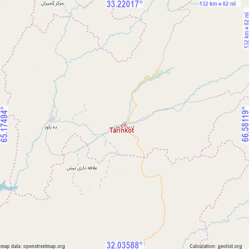
Tarinkot GPS coordinates[2]
32° 37' 47.928" North, 65° 52' 41.016" East
| Map corner | latitude | longitude |
|---|---|---|
| Upper-left | 33.22017°, | 65.17494° |
| Center: | 32.62998°, | 65.87806° |
| Lower-right: | 32.03588°, | 66.58119° |
| Map W x H: | 131.7×131.7 km | = 81.8×81.8mi |
| max Lat: | 38.4435° ⇑86.8% North |
| Tarinkot: | 32.62998° |
| min Lat: | ⇓13.2% South 30.15° |
| min Long | Tarinkot | max Long |
| 61.06667° | 65.87806° | 72.318° |
| W 27%⇐ | ⇒73% E |
Elevation
Elevation of Tarinkot is 1325 m = 4347 ft, and this is 93.4 m = 306 ft below average elevation for this country.
| Max E: |
3068 m = 10066 ft | 51.4% |
| Avg. | 1418.4 m = 4654 ft | |
| Tarinkot | 1325 m = 4347 ft | |
Min E: |
254 m = 833 ft | 48.6% |
See also: Afghanistan elevation on elevation.city.
Geographical zone
Tarinkot is located in North temperate zone (between Tropic of Cancer and the Arctic Circle). Distance of this Northern Tropic circle is 1022.2 km =635.2 mi to South.| Distance of | km | miles | from Tarinkot |
|---|---|---|---|
| North Pole | 6378.9 | 3963.7 | to North |
| Arctic Circle | 3773.1 | 2344.5 | to North |
| Tropic Cancer | 1022.2 | 635.2 | to South |
| Equator | 3628.1 | 2254.4 | to South |


Nearby cities:
15 places around Tarinkot: (largest is in red/bold)
• Babasakhib
109.6 km =68.1 mi,  190°
190°
• Chinār
99.5 km =61.8 mi,  226°
226°
• Chowṉêy
91.4 km =56.8 mi,  23°
23°
• Dê Nārkhēl Kêlay
31.7 km =19.7 mi, 226°
• Kajrān
74.1 km =46 mi,  329°
329°
• Mīzān ‘Alāqahdārī
78.1 km =48.5 mi,  130°
130°
• Mūsá Qal‘ah
108.2 km =67.2 mi,  259°
259°
• Nāyak
84.2 km =52.3 mi,  94°
94°
• Qalāt
113 km =70.2 mi,  121°
121°
• Sar-e Tayghān
99.6 km =61.9 mi,  349°
349°
• Shahr-e Şafā
101 km =62.8 mi,  155°
155°
• Sāyagaz
108.4 km =67.4 mi, 93°
• Uruzgān
77.9 km =48.4 mi,  64°
64°
• Zamtō Kêlay
40.1 km =24.9 mi,  135°
135°
• Zīārat-e Shāh Maqşūd
81.2 km =50.5 mi,  207°
207°
Sources, notices
• [Note1] Compared only with cities in Afghanistan existing in our database
• [Src1] Map data: © OpenStreetMap contributors (CC-BY-SA)
• [Src2] Other city data from geonames.org with taken over terms of usage.
• [Src3] Geographical zone / Annual Mean Temperature by Robert A. Rohde @ Wikipedia
