Sar-e Tayghān geodata
Sar-e Tayghān (Daykundi) is a seat of a second-order administrative division; located in Afghanistan in Asia/Kabul (GMT+4.5) time zone. In our database, there are 93 cities with bigger population. Compared to other cities in Afghanistan, 74.6% of cities are located further ↑North; 75.2% of cities are located further →East and 51.8% of cities have lower elevation than Sar-e Tayghān. Note1


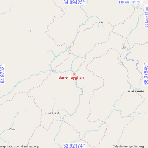
Sar-e Tayghān GPS coordinates[2]
33° 30' 35.928" North, 65° 40' 34.752" East
| Map corner | latitude | longitude |
|---|---|---|
| Upper-left | 34.09425°, | 64.9732° |
| Center: | 33.50998°, | 65.67632° |
| Lower-right: | 32.92174°, | 66.37945° |
| Map W x H: | 130.4×130.4 km | = 81×81mi |
| max Lat: | 38.4435° ⇑74.6% North |
| Sar-e Tayghān: | 33.50998° |
| min Lat: | ⇓25.4% South 30.15° |
| min Long | Sar-e Tayghān | max Long |
| 61.06667° | 65.67632° | 72.318° |
| W 24.8%⇐ | ⇒75.2% E |
Elevation
Elevation of Sar-e Tayghān is 1423 m = 4669 ft, and this is 4.5999999999999 m = 15 ft above average elevation for this country.
| Max E: |
3068 m = 10066 ft | 48.2% |
| Sar-e Tayghān | 1423 m 4669 ft | |
| Avg. | 1418.4 m = 4654 ft | |
Min E: |
254 m = 833 ft | 51.8% |
See also: Afghanistan elevation on elevation.city.
Geographical zone
Sar-e Tayghān is located in North temperate zone (between Tropic of Cancer and the Arctic Circle). Distance of this Northern Tropic circle is 1120 km =695.9 mi to South.| Distance of | km | miles | from Sar-e Tayghān |
|---|---|---|---|
| North Pole | 6281.1 | 3902.9 | to North |
| Arctic Circle | 3675.2 | 2283.7 | to North |
| Tropic Cancer | 1120 | 695.9 | to South |
| Equator | 3726 | 2315.2 | to South |


Nearby cities:
15 places around Sar-e Tayghān: (largest is in red/bold)
• Chowṉêy
57.1 km =35.5 mi,  104°
104°
• Dowlatyār
116.3 km =72.3 mi,  5°
5°
• Dê Nārkhēl Kêlay
119.9 km =74.5 mi,  181°
181°
• Dū Laīnah
109.2 km =67.9 mi,  311°
311°
• Fayrōz Kōh
118.9 km =73.9 mi,  340°
340°
• Kajrān
38.9 km =24.2 mi,  208°
208°
• Khadīr
51.7 km =32.1 mi,  27°
27°
• La‘l
123.5 km =76.7 mi, 26°
• Nīlī
48.2 km =30 mi,  60°
60°
• Pasāband
78.8 km =49 mi,  284°
284°
• Quchanghī
82.8 km =51.4 mi,  42°
42°
• Tarinkot
99.6 km =61.9 mi,  169°
169°
• Taywarah
116.4 km =72.3 mi,  270°
270°
• Uruzgān
110 km =68.4 mi,  126°
126°
• Zamtō Kêlay
134.8 km =83.8 mi,  159°
159°
Sources, notices
• [Note1] Compared only with cities in Afghanistan existing in our database
• [Src1] Map data: © OpenStreetMap contributors (CC-BY-SA)
• [Src2] Other city data from geonames.org with taken over terms of usage.
• [Src3] Geographical zone / Annual Mean Temperature by Robert A. Rohde @ Wikipedia
