Khūgyāṉī geodata
Khūgyāṉī (Kandahar) is a seat of a second-order administrative division; located in Afghanistan in Asia/Kabul (GMT+4.5) time zone. In our database, there are 93 cities with bigger population. Compared to other cities in Afghanistan, 96.5% of cities are located further ↑North; 65.3% of cities are located further →East and 52.1% of cities have higher elevation than Khūgyāṉī. Note1


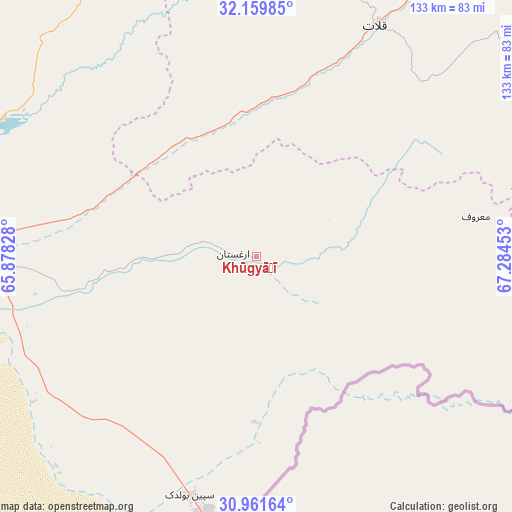
Khūgyāṉī GPS coordinates[2]
31° 33' 45.612" North, 66° 34' 53.04" East
| Map corner | latitude | longitude |
|---|---|---|
| Upper-left | 32.15985°, | 65.87828° |
| Center: | 31.56267°, | 66.5814° |
| Lower-right: | 30.96164°, | 67.28453° |
| Map W x H: | 133.2×133.2 km | = 82.8×82.8mi |
| max Lat: | 38.4435° ⇑96.5% North |
| Khūgyāṉī: | 31.56267° |
| min Lat: | ⇓3.5% South 30.15° |
| min Long | Khūgyāṉī | max Long |
| 61.06667° | 66.5814° | 72.318° |
| W 34.7%⇐ | ⇒65.3% E |
Elevation
Elevation of Khūgyāṉī is 1311 m = 4301 ft, and this is 107.4 m = 352 ft below average elevation for this country.
| Max E: |
3068 m = 10066 ft | 52.1% |
| Avg. | 1418.4 m = 4654 ft | |
| Khūgyāṉī | 1311 m = 4301 ft | |
Min E: |
254 m = 833 ft | 47.9% |
See also: Afghanistan elevation on elevation.city.
Geographical zone
Khūgyāṉī is located in North temperate zone (between Tropic of Cancer and the Arctic Circle). Distance of this Northern Tropic circle is 903.5 km =561.4 mi to South.| Distance of | km | miles | from Khūgyāṉī |
|---|---|---|---|
| North Pole | 6497.6 | 4037.4 | to North |
| Arctic Circle | 3891.7 | 2418.2 | to North |
| Tropic Cancer | 903.5 | 561.4 | to South |
| Equator | 3509.4 | 2180.6 | to South |


Nearby cities:
15 places around Khūgyāṉī: (largest is in red/bold)
• Arghestān
8.7 km =5.4 mi,  267°
267°
• Babasakhib
87.8 km =54.6 mi,  277°
277°
• Dê Nārkhēl Kêlay
131.6 km =81.8 mi,  317°
317°
• Kandahār
82.7 km =51.4 mi, 273°
• Mīzān ‘Alāqahdārī
68.5 km =42.6 mi,  354°
354°
• Nāyak
113.7 km =70.6 mi,  9°
9°
• Pāshmūl
108.7 km =67.5 mi, 269°
• Qalāt
67.8 km =42.1 mi,  27°
27°
• Shahr-e Şafā
36.2 km =22.5 mi, 317°
• Spīn Bōldak
64.3 km =40 mi,  195°
195°
• Sāyagaz
119.3 km =74.1 mi,  20°
20°
• Zamtō Kêlay
97.8 km =60.8 mi,  337°
337°
• Zīārat-e Shāh Maqşūd
114.8 km =71.3 mi,  294°
294°
• Ḩukūmat-e Shīnkaī
85.2 km =52.9 mi,  56°
56°
• ‘Alāqahdārī Aṯghar
75.9 km =47.2 mi,  75°
75°
Sources, notices
• [Note1] Compared only with cities in Afghanistan existing in our database
• [Src1] Map data: © OpenStreetMap contributors (CC-BY-SA)
• [Src2] Other city data from geonames.org with taken over terms of usage.
• [Src3] Geographical zone / Annual Mean Temperature by Robert A. Rohde @ Wikipedia
