Sar Chakān geodata
Sar Chakān (Faryab) is a seat of a second-order administrative division; located in Afghanistan in Asia/Kabul (GMT+4.5) time zone. In our database, there are 93 cities with bigger population. Compared to other cities in Afghanistan, 72.7% of cities are located further ↓South; 78.8% of cities are located further →East and 50.2% of cities have higher elevation than Sar Chakān. Note1


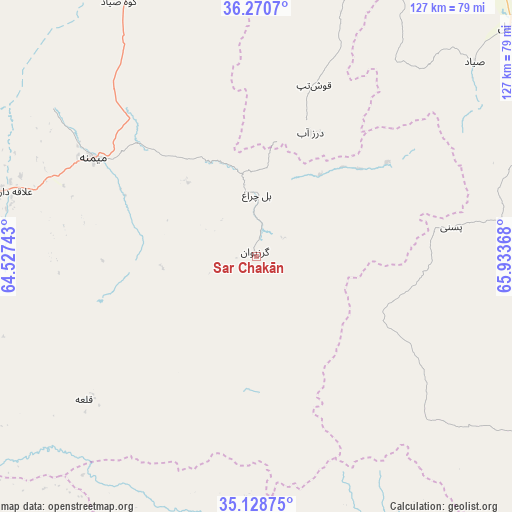
Sar Chakān GPS coordinates[2]
35° 42' 6.372" North, 65° 13' 49.98" East
| Map corner | latitude | longitude |
|---|---|---|
| Upper-left | 36.2707°, | 64.52743° |
| Center: | 35.70177°, | 65.23055° |
| Lower-right: | 35.12875°, | 65.93368° |
| Map W x H: | 127×127 km | = 78.9×78.9mi |
| max Lat: | 38.4435° ⇑27.3% North |
| Sar Chakān: | 35.70177° |
| min Lat: | ⇓72.7% South 30.15° |
| min Long | Sar Chakān | max Long |
| 61.06667° | 65.23055° | 72.318° |
| W 21.2%⇐ | ⇒78.8% E |
Elevation
Elevation of Sar Chakān is 1348 m = 4423 ft, and this is 70.4 m = 231 ft below average elevation for this country.
| Max E: |
3068 m = 10066 ft | 50.2% |
| Avg. | 1418.4 m = 4654 ft | |
| Sar Chakān | 1348 m = 4423 ft | |
Min E: |
254 m = 833 ft | 49.8% |
See also: Afghanistan elevation on elevation.city.
Geographical zone
Sar Chakān is located in North temperate zone (between Tropic of Cancer and the Arctic Circle). Distance of this Northern Tropic circle is 1363.7 km =847.4 mi to South.| Distance of | km | miles | from Sar Chakān |
|---|---|---|---|
| North Pole | 6037.4 | 3751.5 | to North |
| Arctic Circle | 3431.5 | 2132.2 | to North |
| Tropic Cancer | 1363.7 | 847.4 | to South |
| Equator | 3969.7 | 2466.7 | to South |


Nearby cities:
15 places around Sar Chakān: (largest is in red/bold)
• Bal Chirāgh
15.4 km =9.6 mi,  0°
0°
• Chīras
75 km =46.6 mi,  114°
114°
• Darzāb
33.4 km =20.8 mi,  23°
23°
• Dowlatābād
85.9 km =53.4 mi,  341°
341°
• Fayẕābād
73.4 km =45.6 mi,  333°
333°
• Lāsh
54.7 km =34 mi,  228°
228°
• Maymana
47.1 km =29.3 mi,  301°
301°
• Pasnay
48.8 km =30.3 mi,  81°
81°
• Qal‘ah-ye Shahr
35 km =21.7 mi,  119°
119°
• Sangalak-i-Kaisar
84.7 km =52.6 mi,  268°
268°
• Sar-e Pul
85.2 km =52.9 mi,  47°
47°
• Sōzmah Qal‘ah
98.5 km =61.2 mi,  63°
63°
• Tagāw-Bāy
75 km =46.6 mi,  90°
90°
• Şayād
72.3 km =44.9 mi, 48°
• ‘Alāqahdārī-ye Almār
65.1 km =40.5 mi,  284°
284°
Sources, notices
• [Note1] Compared only with cities in Afghanistan existing in our database
• [Src1] Map data: © OpenStreetMap contributors (CC-BY-SA)
• [Src2] Other city data from geonames.org with taken over terms of usage.
• [Src3] Geographical zone / Annual Mean Temperature by Robert A. Rohde @ Wikipedia
