Chīras geodata
Chīras (Sar-e Pol) is a populated place; located in Afghanistan in Asia/Kabul (GMT+4.5) time zone. With population of 12,779 people, there are 55 cities with bigger population in this country. Compared to other cities in Afghanistan, 67.5% of cities are located further ↓South; 72% of cities are located further →East and 97.7% of cities have lower elevation than Chīras. Note1


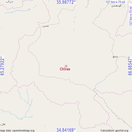
Chīras GPS coordinates[2]
35° 25' 0.264" North, 65° 58' 56.424" East
| Map corner | latitude | longitude |
|---|---|---|
| Upper-left | 35.98772°, | 65.27922° |
| Center: | 35.41674°, | 65.98234° |
| Lower-right: | 34.84169°, | 66.68547° |
| Map W x H: | 127.4×127.4 km | = 79.2×79.2mi |
| max Lat: | 38.4435° ⇑32.5% North |
| Chīras: | 35.41674° |
| min Lat: | ⇓67.5% South 30.15° |
| min Long | Chīras | max Long |
| 61.06667° | 65.98234° | 72.318° |
| W 28%⇐ | ⇒72% E |
Elevation
Elevation of Chīras is 2691 m = 8829 ft, and this is 1272.6 m = 4175 ft above average elevation for this country.
| Max E: |
3068 m = 10066 ft | 2.3% |
| Chīras | 2691 m 8829 ft | |
| Avg. | 1418.4 m = 4654 ft | |
Min E: |
254 m = 833 ft | 97.7% |
See also: Afghanistan elevation on elevation.city.
Geographical zone
Chīras is located in North temperate zone (between Tropic of Cancer and the Arctic Circle). Distance of this Northern Tropic circle is 1332.1 km =827.7 mi to South.| Distance of | km | miles | from Chīras |
|---|---|---|---|
| North Pole | 6069.1 | 3771.2 | to North |
| Arctic Circle | 3463.2 | 2151.9 | to North |
| Tropic Cancer | 1332.1 | 827.7 | to South |
| Equator | 3938 | 2447 | to South |


Nearby cities:
15 places around Chīras: (largest is in red/bold)
• Bal Chirāgh
82.6 km =51.3 mi,  304°
304°
• Darzāb
82.8 km =51.4 mi,  318°
318°
• Dowlatyār
97.8 km =60.8 mi,  190°
190°
• Lab-Sar
102.8 km =63.9 mi,  48°
48°
• Larkird
62.3 km =38.7 mi,  82°
82°
• La‘l
105.3 km =65.4 mi,  165°
165°
• Pasnay
43.6 km =27.1 mi,  333°
333°
• Qal‘ah-ye Shahr
40.3 km =25 mi,  291°
291°
• Sang-e Chārak
63.3 km =39.3 mi,  40°
40°
• Sar Chakān
75 km =46.6 mi, 294°
• Sar-e Pul
88.9 km =55.2 mi,  357°
357°
• Sōzmah Qal‘ah
78.6 km =48.8 mi,  15°
15°
• Tagāw-Bāy
32.2 km =20 mi,  12°
12°
• Tukzār
71.2 km =44.2 mi,  33°
33°
• Şayād
81.1 km =50.4 mi,  350°
350°
Sources, notices
• [Note1] Compared only with cities in Afghanistan existing in our database
• [Src1] Map data: © OpenStreetMap contributors (CC-BY-SA)
• [Src2] Other city data from geonames.org with taken over terms of usage.
• [Src3] Geographical zone / Annual Mean Temperature by Robert A. Rohde @ Wikipedia
