La‘l geodata
La‘l (Ghowr) is a seat of a second-order administrative division; located in Afghanistan in Asia/Kabul (GMT+4.5) time zone. In our database, there are 93 cities with bigger population. Compared to other cities in Afghanistan, 54.7% of cities are located further ↑North; 68.2% of cities are located further →East and 98.7% of cities have lower elevation than La‘l. Note1


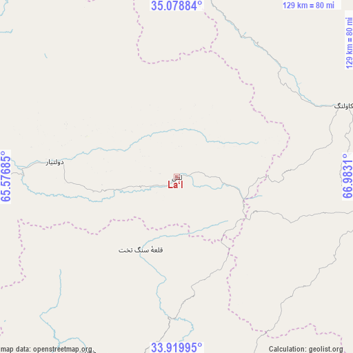
La‘l GPS coordinates[2]
34° 30' 5.076" North, 66° 16' 47.892" East
| Map corner | latitude | longitude |
|---|---|---|
| Upper-left | 35.07884°, | 65.57685° |
| Center: | 34.50141°, | 66.27997° |
| Lower-right: | 33.91995°, | 66.9831° |
| Map W x H: | 128.9×128.9 km | = 80.1×80.1mi |
| max Lat: | 38.4435° ⇑54.7% North |
| La‘l: | 34.50141° |
| min Lat: | ⇓45.3% South 30.15° |
| min Long | La‘l | max Long |
| 61.06667° | 66.27997° | 72.318° |
| W 31.8%⇐ | ⇒68.2% E |
Elevation
Elevation of La‘l is 2797 m = 9177 ft, and this is 1378.6 m = 4523 ft above average elevation for this country.
| Max E: |
3068 m = 10066 ft | 1.3% |
| La‘l | 2797 m 9177 ft | |
| Avg. | 1418.4 m = 4654 ft | |
Min E: |
254 m = 833 ft | 98.7% |
See also: Afghanistan elevation on elevation.city.
Geographical zone
La‘l is located in North temperate zone (between Tropic of Cancer and the Arctic Circle). Distance of this Northern Tropic circle is 1230.3 km =764.5 mi to South.| Distance of | km | miles | from La‘l |
|---|---|---|---|
| North Pole | 6170.9 | 3834.4 | to North |
| Arctic Circle | 3565 | 2215.2 | to North |
| Tropic Cancer | 1230.3 | 764.5 | to South |
| Equator | 3836.2 | 2383.7 | to South |


Nearby cities:
15 places around La‘l: (largest is in red/bold)
• Bāmyān
145.9 km =90.7 mi,  75°
75°
• Chowṉêy
124.4 km =77.3 mi,  180°
180°
• Chīras
105.3 km =65.4 mi,  345°
345°
• Dowlatyār
45 km =28 mi,  277°
277°
• Dū Laīnah
142.5 km =88.5 mi,  254°
254°
• Fayrōz Kōh
94.3 km =58.6 mi,  271°
271°
• Khadīr
71.8 km =44.6 mi,  206°
206°
• Larkird
115.3 km =71.6 mi,  17°
17°
• Nayak
66.8 km =41.5 mi,  67°
67°
• Nīlī
87.8 km =54.6 mi,  189°
189°
• Panjāb
69.3 km =43.1 mi,  100°
100°
• Qal‘ah-ye Shahr
133.2 km =82.8 mi,  330°
330°
• Quchanghī
48.9 km =30.4 mi, 180°
• Sar-e Tayghān
123.5 km =76.7 mi, 206°
• Tagāw-Bāy
134.7 km =83.7 mi, 351°
Sources, notices
• [Note1] Compared only with cities in Afghanistan existing in our database
• [Src1] Map data: © OpenStreetMap contributors (CC-BY-SA)
• [Src2] Other city data from geonames.org with taken over terms of usage.
• [Src3] Geographical zone / Annual Mean Temperature by Robert A. Rohde @ Wikipedia
