Panbang geodata
Panbang (Shemgang) is a populated place; located in Bhutan in Asia/Thimphu (GMT+6) time zone. With population of 1,360 people, there are 19 cities with bigger population in this country. Compared to other cities in Bhutan, 81.5% of cities are located further ↑North; 66.7% of cities are located further ←West and 92.6% of cities have higher elevation than Panbang. Note1


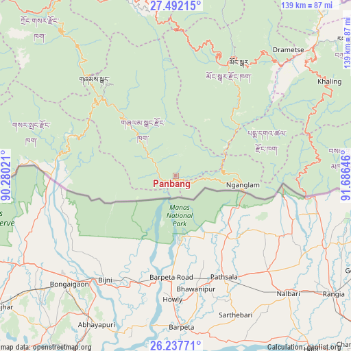
Panbang GPS coordinates[2]
26° 52' 0.012" North, 90° 58' 59.988" East
| Map corner | latitude | longitude |
|---|---|---|
| Upper-left | 27.49215°, | 90.28021° |
| Center: | 26.86667°, | 90.98333° |
| Lower-right: | 26.23771°, | 91.68646° |
| Map W x H: | 139.5×139.5 km | = 86.7×86.7mi |
| max Lat: | 27.90372° ⇑81.5% North |
| Panbang: | 26.86667° |
| min Lat: | ⇓18.5% South 26.78333° |
| min Long | Panbang | max Long |
| 89.09951° | 90.98333° | 92.1° |
| W 66.7%⇐ | ⇒33.3% E |
Elevation
Elevation of Panbang is 214 m = 702 ft, and this is 1164.2 m = 3820 ft below average elevation for this country.
| Max E: |
2761 m = 9058 ft | 92.6% |
| Avg. | 1378.2 m = 4522 ft | |
| Panbang | 214 m = 702 ft | |
Min E: |
145 m = 476 ft | 7.4% |
See also: Bhutan elevation on elevation.city.
Geographical zone
Panbang is located in North temperate zone (between Tropic of Cancer and the Arctic Circle). Distance of this Northern Tropic circle is 381.4 km =237 mi to South.| Distance of | km | miles | from Panbang |
|---|---|---|---|
| North Pole | 7019.8 | 4361.9 | to North |
| Arctic Circle | 4413.9 | 2742.7 | to North |
| Tropic Cancer | 381.4 | 237 | to South |
| Equator | 2987.3 | 1856.2 | to South |


Nearby cities:
15 places around Panbang: (largest is in red/bold)
• Bhangtar
73 km =45.4 mi,  94°
94°
• Daga
112.1 km =69.7 mi,  281°
281°
• Daifam
110.8 km =68.8 mi, 88°
• Jakar
79.2 km =49.2 mi,  343°
343°
• Lhuentse
91.3 km =56.7 mi,  12°
12°
• Mongar
52 km =32.3 mi,  29°
29°
• Nganglam
28 km =17.4 mi,  109°
109°
• Pemagatshel
45.8 km =28.5 mi,  65°
65°
• Samdrup Jongkhar
52.3 km =32.5 mi,  98°
98°
• Sarpang
71 km =44.1 mi,  269°
269°
• Shemgang
50.5 km =31.4 mi,  320°
320°
• Trashi Yangtse
97.2 km =60.4 mi, 31°
• Trashigang
76.7 km =47.7 mi,  47°
47°
• Trongsa
85 km =52.8 mi,  326°
326°
• Tsirang
87 km =54.1 mi, 281°
Sources, notices
• [Note1] Compared only with cities in Bhutan existing in our database
• [Src1] Map data: © OpenStreetMap contributors (CC-BY-SA)
• [Src2] Other city data from geonames.org with taken over terms of usage.
• [Src3] Geographical zone / Annual Mean Temperature by Robert A. Rohde @ Wikipedia
