Dukwe geodata
Dukwe (North-East) is a populated place; located in Botswana in Africa/Gaborone (GMT+2) time zone. With population of 2,037 people, there are 54 cities with bigger population in this country. Compared to other cities in Botswana, 87.6% of cities are located further ↓South; 61.9% of cities are located further ←West and 61% of cities have higher elevation than Dukwe. Note1


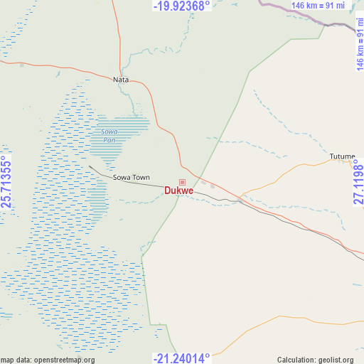
Dukwe GPS coordinates[2]
20° 34' 59.988" South, 26° 25' 0.012" East
| Map corner | latitude | longitude |
|---|---|---|
| Upper-left | -19.92368°, | 25.71355° |
| Center: | -20.58333°, | 26.41667° |
| Lower-right: | -21.24014°, | 27.1198° |
| Map W x H: | 146.4×146.4 km | = 91×91mi |
| max Lat: | -17.80165° ⇑12.4% North |
| Dukwe: | -20.58333° |
| min Lat: | ⇓87.6% South -26.9° |
| min Long | Dukwe | max Long |
| 20.06667° | 26.41667° | 28.74946° |
| W 61.9%⇐ | ⇒38.1% E |
Elevation
Elevation of Dukwe is 961 m = 3153 ft, and this is 54 m = 177 ft below average elevation for this country.
| Max E: |
1406 m = 4613 ft | 61% |
| Avg. | 1015 m = 3330 ft | |
| Dukwe | 961 m = 3153 ft | |
Min E: |
676 m = 2218 ft | 39% |
See also: Botswana elevation on elevation.city.
Geographical zone
Dukwe is located in South Torrid zone (between Equator and Tropic of Capricorn). Distance of this Southern Tropic circle is 317.3 km =197.2 mi to South.| Distance of | km | miles | from Dukwe |
|---|---|---|---|
| Equator | 2288.7 | 1422.1 | to North |
| Tropic Capricorn | 317.3 | 197.2 | to South |
| Antarctic Circle | 5112.5 | 3176.8 | to South |
| South Pole | 7718.4 | 4796 | to South |


Nearby cities:
15 places around Dukwe: (largest is in red/bold)
• Francistown
130.8 km =81.3 mi,  119°
119°
• Gweta
131.1 km =81.5 mi,  289°
289°
• Kalakamati
93.1 km =57.8 mi,  90°
90°
• Letlhakane
126 km =78.3 mi,  222°
222°
• Makaleng
96.8 km =60.1 mi,  111°
111°
• Masunga
107.5 km =66.8 mi, 92°
• Mathambgwane
105.3 km =65.4 mi, 115°
• Mopipi
172.7 km =107.3 mi,  247°
247°
• Mosetse
30.5 km =19 mi,  127°
127°
• Nata
47.5 km =29.5 mi,  329°
329°
• Orapa
135 km =83.9 mi,  233°
233°
• Sebina
92.2 km =57.3 mi, 109°
• Serowe
202.9 km =126.1 mi,  171°
171°
• Sua
63.5 km =39.5 mi,  339°
339°
• Tonota
144.5 km =89.8 mi, 131°
Sources, notices
• [Note1] Compared only with cities in Botswana existing in our database
• [Src1] Map data: © OpenStreetMap contributors (CC-BY-SA)
• [Src2] Other city data from geonames.org with taken over terms of usage.
• [Src3] Geographical zone / Annual Mean Temperature by Robert A. Rohde @ Wikipedia
