Bélel geodata
Bélel (Adamaoua) is a populated place; located in Cameroon in Africa/Douala (GMT+1) time zone. With population of 6,831 people, there are 88 cities with bigger population in this country. Compared to other cities in Cameroon, 83.6% of cities are located further ↓South; 91.8% of cities are located further ←West and 95.1% of cities have lower elevation than Bélel. Note1


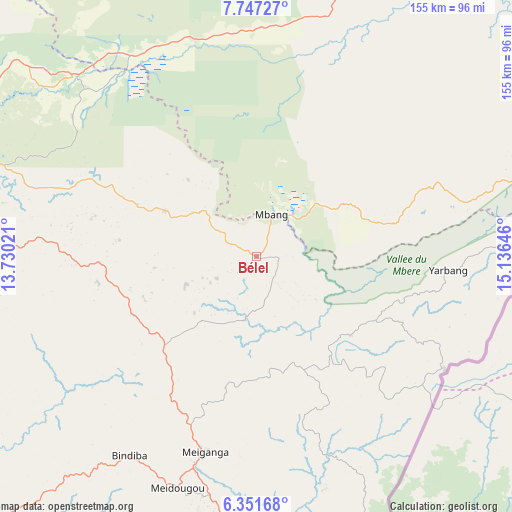
Bélel GPS coordinates[2]
7° 3' 0" North, 14° 25' 59.988" East
| Map corner | latitude | longitude |
|---|---|---|
| Upper-left | 7.74727°, | 13.73021° |
| Center: | 7.05°, | 14.43333° |
| Lower-right: | 6.35168°, | 15.13646° |
| Map W x H: | 155.2×155.2 km | = 96.4×96.4mi |
| max Lat: | 12.57535° ⇑16.4% North |
| Bélel: | 7.05° |
| min Lat: | ⇓83.6% South 2.35° |
| min Long | Bélel | max Long |
| 8.8724° | 14.43333° | 15.23288° |
| W 91.8%⇐ | ⇒8.2% E |
Elevation
Elevation of Bélel is 1448 m = 4751 ft, and this is 774.1 m = 2540 ft above average elevation for this country.
| Max E: |
1687 m = 5535 ft | 4.9% |
| Bélel | 1448 m 4751 ft | |
| Avg. | 673.9 m = 2211 ft | |
Min E: |
1 m = 3 ft | 95.1% |
See also: Cameroon elevation on elevation.city.
Geographical zone
Bélel is located in North Torrid zone (between Equator and Tropic of Cancer). Distance of Equator is 783.9 km =487.1 mi to South.| Distance of | km | miles | from Bélel |
|---|---|---|---|
| North Pole | 9223.2 | 5731 | to North |
| Arctic Circle | 6617.3 | 4111.8 | to North |
| Tropic Cancer | 1822 | 1132.1 | to North |
| Equator | 783.9 | 487.1 | to South |


Nearby cities:
15 places around Bélel: (largest is in red/bold)
• Bélabo
266.6 km =165.7 mi,  208°
208°
• Bétaré Oya
165.8 km =103 mi,  193°
193°
• Djohong
38 km =23.6 mi,  129°
129°
• Garoua
275.1 km =170.9 mi,  335°
335°
• Garoua Boulaï
130.4 km =81 mi,  174°
174°
• Kontcha
263.1 km =163.5 mi,  292°
292°
• Lagdo
238.7 km =148.3 mi, 339°
• Meïganga
61.1 km =38 mi, 193°
• Ngaoundéré
98.6 km =61.3 mi, 288°
• Pitoa
279 km =173.4 mi, 338°
• Poli
205.9 km =127.9 mi,  320°
320°
• Rey Bouba
182.6 km =113.5 mi,  351°
351°
• Tcholliré
153.1 km =95.1 mi, 349°
• Tibati
209.6 km =130.2 mi,  251°
251°
• Tignère
199.8 km =124.1 mi,  280°
280°
Sources, notices
• [Note1] Compared only with cities in Cameroon existing in our database
• [Src1] Map data: © OpenStreetMap contributors (CC-BY-SA)
• [Src2] Other city data from geonames.org with taken over terms of usage.
• [Src3] Geographical zone / Annual Mean Temperature by Robert A. Rohde @ Wikipedia
