Ngaoundéré geodata
Ngaoundéré (Adamaoua) is a seat of a first-order administrative division; located in Cameroon in Africa/Douala (GMT+1) time zone. With population of 231,357 people, there are 8 cities with bigger population in this country. Compared to other cities in Cameroon, 84.4% of cities are located further ↓South; 81.1% of cities are located further ←West and 80.3% of cities have lower elevation than Ngaoundéré. Note1


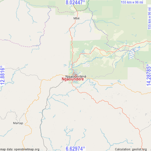
Ngaoundéré GPS coordinates[2]
7° 19' 39.54" North, 13° 35' 4.992" East
| Map corner | latitude | longitude |
|---|---|---|
| Upper-left | 8.02447°, | 12.8816° |
| Center: | 7.32765°, | 13.58472° |
| Lower-right: | 6.62974°, | 14.28785° |
| Map W x H: | 155.1×155.1 km | = 96.4×96.4mi |
| max Lat: | 12.57535° ⇑15.6% North |
| Ngaoundéré: | 7.32765° |
| min Lat: | ⇓84.4% South 2.35° |
| min Long | Ngaoundéré | max Long |
| 8.8724° | 13.58472° | 15.23288° |
| W 81.1%⇐ | ⇒18.9% E |
Elevation
Elevation of Ngaoundéré is 1128 m = 3701 ft, and this is 454.1 m = 1490 ft above average elevation for this country.
| Max E: |
1687 m = 5535 ft | 19.7% |
| Ngaoundéré | 1128 m 3701 ft | |
| Avg. | 673.9 m = 2211 ft | |
Min E: |
1 m = 3 ft | 80.3% |
See also: Ngaoundéré elevation on elevation.city.
Geographical zone
Ngaoundéré is located in North Torrid zone (between Equator and Tropic of Cancer). Distance of Equator is 814.8 km =506.3 mi to South.| Distance of | km | miles | from Ngaoundéré |
|---|---|---|---|
| North Pole | 9192.3 | 5711.8 | to North |
| Arctic Circle | 6586.4 | 4092.6 | to North |
| Tropic Cancer | 1791.2 | 1113 | to North |
| Equator | 814.8 | 506.3 | to South |


Nearby cities:
15 places around Ngaoundéré: (largest is in red/bold)
• Banyo
205.4 km =127.6 mi,  251°
251°
• Bélel
98.6 km =61.3 mi,  108°
108°
• Bétaré Oya
199.8 km =124.1 mi,  163°
163°
• Djohong
134.8 km =83.8 mi, 114°
• Garoua
220.4 km =137 mi,  354°
354°
• Garoua Boulaï
192.8 km =119.8 mi,  146°
146°
• Kontcha
165 km =102.5 mi,  295°
295°
• Lagdo
192.6 km =119.7 mi,  2°
2°
• Meïganga
119.9 km =74.5 mi,  138°
138°
• Pitoa
228.8 km =142.2 mi,  357°
357°
• Poli
133.1 km =82.7 mi,  343°
343°
• Rey Bouba
163.2 km =101.4 mi,  23°
23°
• Tcholliré
135.7 km =84.3 mi,  28°
28°
• Tibati
142.6 km =88.6 mi,  227°
227°
• Tignère
103.2 km =64.1 mi,  272°
272°
Sources, notices
• [Note1] Compared only with cities in Cameroon existing in our database
• [Src1] Map data: © OpenStreetMap contributors (CC-BY-SA)
• [Src2] Other city data from geonames.org with taken over terms of usage.
• [Src3] Geographical zone / Annual Mean Temperature by Robert A. Rohde @ Wikipedia
